Table of Contents
Quick Links
Table of Contents

Related Manuals for Garmin G1000:Socata


Summary of Contents for Garmin G1000:Socata
- Page 1 Socata TBM 850...
- Page 2 Except as expressly provided herein, no part of this manual may be reproduced, copied, transmitted, disseminated, downloaded or stored in any storage medium, for any purpose without the express written permission of Garmin. Garmin hereby grants permission to download a single copy of this manual and of any revision to this manual onto a hard drive or other electronic storage medium to be viewed for personal use, provided that such electronic or printed copy of this manual or revision must contain the complete text of this copyright notice and provided further that any unauthorized commercial distribution of this manual or any revision hereto is strictly prohibited.
- Page 3 Garmin retains the exclusive right to repair or replace the unit or software, or to offer a full refund of the purchase price, at its sole discretion.
- Page 4 Lamp(s) inside this product may contain mercury (HG) and must be recycled or disposed of WARNING: according to local, state, or federal laws. For more information, refer to our website at www.garmin.com/ aboutGarmin/environment/disposal.jsp. Because of anomalies in the earth’s magnetic field, operating the G1000 within the following WARNING: areas could result in loss of reliable attitude and heading indications.
- Page 5 The GPS system is subject to changes which could affect the accuracy and performance of all GPS equipment. Portions of the Garmin G1000 utilize GPS as a precision electronic NAVigation AID (NAVAID). Therefore, as with all NAVAIDs, information presented by the G1000 can be misused or misinterpreted and, therefore, become unsafe.
- Page 6 REVISION INFORMATION Record of Revisions Part Number Revision Date Page Range Description 190-00709-00 11/2/07 Initial Release Garmin G1000 Pilot’s Guide for the Socata TBM 850 190-00709-00 Rev. A...
-
Page 7: Table Of Contents
2.3 PFD Annunciations and Alerting Functions ..2-30 .....4-19 Auto-Tuning a NAV Frequency from the MFD ............2-30 System Alerting ...........4-24 Marker Beacon Receiver ..........2-31 Traffic Annunciation .............4-25 ADF/DME Tuning 190-00709-00 Rev. A Garmin G1000 Pilot’s Guide for the Socata TBM 850... - Page 8 Principles of Pulsed Airborne Weather Radar 5.3 Waypoints............5-30 ...........6-34 Safe Operating Distance ..............5-31 Airports ...........6-34 Basic Antenna Tilt Setup ............5-37 Intersections ......6-36 Weather Mapping and Interpretation ..............5-39 NDBs ......6-49 Ground Mapping and Interpretation Garmin G1000 Pilot’s Guide for the Socata TBM 850 190-00709-00 Rev. A...
- Page 9 Heading Select Mode (HDG) ............A-1 CAS Messages ......7-26 Navigation Mode (GPS, VOR, LOC) .........A-3 Comparator Annunciations ......7-28 Approach Mode (GPS, VAPP, LOC) ......A-4 Reversionary Sensor Annunciations ..........7-30 Backcourse Mode (BC) 190-00709-00 Rev. A Garmin G1000 Pilot’s Guide for the Socata TBM 850...
- Page 10 .........A-21 Other G1000 Aural Alerts SD Card Use ..............B-1 ...........B-1 Jeppesen Databases .............B-2 Garmin Databases Glossary................C-1 Frequently Asked Questions .........D-1 Map Symbols ..............E-1 INDEX Index ................I-1 viii Garmin G1000 Pilot’s Guide for the Socata TBM 850 190-00709-00 Rev. A...
-
Page 11: Section 1 System Overview
NOTE: In the aircraft, the GFC 700 Automated Flight Control System (AFCS) provides the Flight Director (FD), Autopilot (AP), and Yaw Damper (YD) functions of the G1000 system. 190-00709-00 Rev. A Garmin G1000 Pilot’s Guide for the Socata TBM 850... -
Page 12: Line Replaceable Units (Lru)
Each GIA 63W is paired with the on-side PFD via HSDB connection. The GIA 63Ws are not paired together and do not communicate with each other directly. Garmin G1000 Pilot’s Guide for the Socata TBM 850 190-00709-00 Rev. A... - Page 13 • GMU 44 – Measures local magnetic field. Data is sent to the GRS 77 for processing to determine aircraft magnetic heading. This unit receives power directly from the GRS 77 and communicates with the GRS 77, using an RS-485 digital interface. 190-00709-00 Rev. A Garmin G1000 Pilot’s Guide for the Socata TBM 850...
- Page 14 MFD via HSDB connection. A subscription to the XM Satellite Radio service is required to enable the GDL 69A capability. • GWX 68 – Provides airborne weather and ground mapped radar data to the MFD, through the GDL 69A, via HSDB connection. Garmin G1000 Pilot’s Guide for the Socata TBM 850 190-00709-00 Rev. A...
- Page 15 • GA 36 and GA 37 – The GA 36 is a through-mount GPS/WAAS antenna. The GA 37 is a through-mount GPS/ WAAS antenna with XM/Datalink. GA 36 GA 37 190-00709-00 Rev. A Garmin G1000 Pilot’s Guide for the Socata TBM 850...
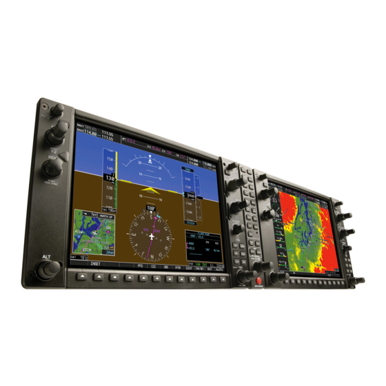
- Page 16 Servo Management GSA 81 (Pitch) GSA 81 GTX 33D GTX 33 (Roll) GSA 81 (Yaw) GEA 71 #1 GEA 71 #2 Figure 1-1 Example G1000 System (LRU Configuration) Garmin G1000 Pilot’s Guide for the Socata TBM 850 190-00709-00 Rev. A...
-
Page 17: G1000 Controls
The G1000 system controls are located on the PFD and MFD bezels, MFD Control Unit, AFCS Control Unit and audio panel. The controls for the PFD and MFD are discussed within the following pages of this section. PFD CONTROLS Figure 1-2 PFD Controls 190-00709-00 Rev. A Garmin G1000 Pilot’s Guide for the Socata TBM 850... - Page 18 If a flight plan is not used, both the desired airport and the desired procedure may be selected. ENT Key – Validates or confirms a menu selection or data entry. Garmin G1000 Pilot’s Guide for the Socata TBM 850 190-00709-00 Rev. A...
-
Page 19: Controls Associated With The Mfd
Theses procedures can then be loaded into the active flight plan. If a flight plan is not used, both the desired airport and the desired procedure may be selected. 190-00709-00 Rev. A Garmin G1000 Pilot’s Guide for the Socata TBM 850... -
Page 20: Afcs Controls
HDG Key – Selects/deselects the Heading Select mode. APR Key – Selects/deselects the Approach mode. NAV Key – Selects/deselects the Navigation mode. 1-10 Garmin G1000 Pilot’s Guide for the Socata TBM 850 190-00709-00 Rev. A... - Page 21 MET (Manual Electric Trim) Switch are additional AFCS controls and are located in the cockpit, separately from the AFCS Control Unit. These are discussed in detail in the AFCS section. 1-11 190-00709-00 Rev. A Garmin G1000 Pilot’s Guide for the Socata TBM 850...
-
Page 22: Audio Panel Controls
COM2 Key, or COM1 can be added by pressing the COM1 Key. COM2 – When selected, audio from the #2 Com receiver can be heard. COM3 MIC – Not used on some aircraft.. 1-12 Garmin G1000 Pilot’s Guide for the Socata TBM 850 190-00709-00 Rev. A... - Page 23 MSTR Knob – The Master Volume Control adjusts volume for the blended NAV, COM, and intercom audio. Reversionary Mode Button – Pressing manually selects Reversionary Mode. 1-13 190-00709-00 Rev. A Garmin G1000 Pilot’s Guide for the Socata TBM 850...
-
Page 24: Secure Digital Cards
• Gently press on the SD card to release the spring latch and eject the card. Ensure that the G1000 system is powered off before inserting the SD card SD Card Slots Figure 1-6 Display Bezel SD Card Slots 1-14 Garmin G1000 Pilot’s Guide for the Socata TBM 850 190-00709-00 Rev. A... -
Page 25: System Power-Up
(to ensure that no databases have expired), the pilot is prompted to continue. Pressing the ENT Key acknowledges this information and displays the Auxiliary (AUX) Weight Planning Page. Figure 1-7 PFD Initialization Figure 1-8 MFD Power-up Page 1-15 190-00709-00 Rev. A Garmin G1000 Pilot’s Guide for the Socata TBM 850... -
Page 26: System Operation
(see Figure 1-10). Transition to reversionary mode should be straightforward for the pilot, for flight parameters are presented in the same format as in normal mode. 1-16 Garmin G1000 Pilot’s Guide for the Socata TBM 850 190-00709-00 Rev. A... - Page 27 Refer to the Appendices for specific AHRS alert information. NOTE: Aggressive maneuvering in any of the three reversionary modes listed in Table 1-1 can degrade AHRS NOTE: accuracy. 1-17 190-00709-00 Rev. A Garmin G1000 Pilot’s Guide for the Socata TBM 850...
- Page 28 GPS receiver. An alert message informs the pilot of the use of the backup GPS path. If both GPS inputs fail, the AHRS continues to operate in reversionary No-GPS mode so long as the air data and magnetometer inputs are available and valid. 1-18 Garmin G1000 Pilot’s Guide for the Socata TBM 850 190-00709-00 Rev. A...
-
Page 29: G1000 System Annunciations
(Figure 1-14 displays all possible flags and responsible LRUs). Upon G1000 power-up, certain windows remain invalid as equipment begins to initialize. All windows should be operational within one minute of power-up. If any window remains flagged, the G1000 System should be serviced by a Garmin- authorized repair facility. -
Page 30: Softkey Function
Displays terrain information on Inset Map NEXRAD Displays NEXRAD weather and coverage information on Inset Map (optional feature) XM LTNG Displays XM lightning information on Inset Map (optional feature) 1-20 Garmin G1000 Pilot’s Guide for the Socata TBM 850 190-00709-00 Rev. A... - Page 31 ADF , ADF Mode selection, ADF volume control, and selection of the DME XPDR Displays transponder mode selection softkeys XPDR1 Selects the #1 transponder as active XPDR2 Selects the #2 transponder as active 1-21 190-00709-00 Rev. A Garmin G1000 Pilot’s Guide for the Socata TBM 850...
- Page 32 Displays Nearest Airports Window Displays Messages Window Figure 1-16 Top Level PFD Softkeys STRMSCP Select the BACK Softkey to return to the top-level softkeys. Figure 1-17 INSET Softkeys 1-22 Garmin G1000 Pilot’s Guide for the Socata TBM 850 190-00709-00 Rev. A...
- Page 33 Figure 1-19 PFD Configuration Softkeys Press the BACK Softkey to return to the top-level softkeys. Press the BACK Softkey to return to the previous level softkeys. Figure 1-20 XPDR Softkeys 1-23 190-00709-00 Rev. A Garmin G1000 Pilot’s Guide for the Socata TBM 850...
- Page 34 DCLTR-2: Declutters land and SUA data DCLTR-3: Removes everything except the active flight plan When available, displays optional airport and terminal procedure charts SHW CHRT CHKLIST When available, displays optional checklists 1-24 Garmin G1000 Pilot’s Guide for the Socata TBM 850 190-00709-00 Rev. A...
-
Page 35: Gps Receiver Operation
2) Use the small FMS Knob to select GPS Status Page. Selecting the GPS receiver for which data may be reviewed 1) Use the FMS Knob to select the AUX - GPS Status Page. 1-25 190-00709-00 Rev. A Garmin G1000 Pilot’s Guide for the Socata TBM 850... - Page 36 Each satellite is represented by an oval containing the Pseudo-random noise (PRN) number (i.e., satellite identification number). Satellites whose signals are currently being used are represented by solid ovals. • Satellite signal information status 1-26 Garmin G1000 Pilot’s Guide for the Socata TBM 850 190-00709-00 Rev. A...
- Page 37 FAF, the missed approach procedure must be flown. Predicting RAIM availability 1) Select the GPS Status Page. 2) If necessary, select the RAIM Softkey. 1-27 190-00709-00 Rev. A Garmin G1000 Pilot’s Guide for the Socata TBM 850...
- Page 38 • ‘RAIM AVAILABLE’—RAIM is predicted to be available for the specified waypoint, time, and date • ‘RAIM NOT AVAILABLE’—RAIM is predicted to be unavailable for the specified waypoint, time, and date 1-28 Garmin G1000 Pilot’s Guide for the Socata TBM 850 190-00709-00 Rev. A...
-
Page 39: Accessing G1000 Functionality
2) Turn the FMS Knob to scroll through a list of available options (a scroll bar appears to the right of the window when the option list is longer than the window). 3) Press the ENT Key to select the desired option. 1-29 190-00709-00 Rev. A Garmin G1000 Pilot’s Guide for the Socata TBM 850... -
Page 40: Mfd Page Groups
Selecting a page using the FMS Knob: 1) Turn the large FMS Knob until the desired page group is selected. 2) Turn the small FMS Knob until the desired page is selected. 1-30 Garmin G1000 Pilot’s Guide for the Socata TBM 850 190-00709-00 Rev. A... - Page 41 (STAR softkey) - Approach Information (APR softkey) - Weather Information (WX softkey) Intersection Information NDB Information VOR Information Airport Information User Waypoint Information Screens Figure 1-27 Waypoint Pages 1-31 190-00709-00 Rev. A Garmin G1000 Pilot’s Guide for the Socata TBM 850...
- Page 42 System Status Figure 1-28 Auxiliary Pages Nearest Pages (NRST) Nearest Airports Nearest Intersections Nearest NDB Nearest VOR Nearest User Waypoints Nearest Frequencies Nearest Airspaces Figure 1-29 Nearest Pages 1-32 Garmin G1000 Pilot’s Guide for the Socata TBM 850 190-00709-00 Rev. A...
- Page 43 For some of these pages (Airport Information screens, XM Satellite screens, Procedure Pages), the title of the page may change while the page icon remains the same. 1-33 190-00709-00 Rev. A Garmin G1000 Pilot’s Guide for the Socata TBM 850...
-
Page 44: Mfd System Pages
UTC (also called “GMT” or “Zulu”) date and time are calculated directly from the GPS satellites signals and cannot be changed. When using a local time format, designate the offset by adding or subtracting the desired number of hours. 1-34 Garmin G1000 Pilot’s Guide for the Socata TBM 850 190-00709-00 Rev. A... - Page 45 Affects the temperature display on the Trip Planning Page. Does not affect the Engine Indicating System display. • Fuel and fuel flow (gallons, imperial gallons, liters, pounds, kilograms) Affects all fuel and fuel flow displays. 1-35 190-00709-00 Rev. A Garmin G1000 Pilot’s Guide for the Socata TBM 850...
- Page 46 2) Turn the large FMS Knob to highlight the desired field in the Airspace Alerts Box. 3) Turn the small FMS Knob clockwise to turn the airspace alert ON or counterclockwise to turn the alert OFF. 1-36 Garmin G1000 Pilot’s Guide for the Socata TBM 850 190-00709-00 Rev. A...
- Page 47 0.3 nm during an approach. Note that the Receiver Autonomous Integrity Monitoring (RAIM) protection limits follow the selected CDI range and corresponding flight phases. 1-37 190-00709-00 Rev. A Garmin G1000 Pilot’s Guide for the Socata TBM 850...
- Page 48 3) Turn the small FMS Knob to display and scroll through the runway options (any, hard only, hard/soft, water) and press the ENT Key when the desired selection is highlighted. 1-38 Garmin G1000 Pilot’s Guide for the Socata TBM 850 190-00709-00 Rev. A...
- Page 49 System Setup Page in the box labeled ‘Pilot Profile’. From here, pilot profiles may be created, selected, renamed, or deleted. Figure 1-33 Pilot Profiles (System Setup Page) 1-39 190-00709-00 Rev. A Garmin G1000 Pilot’s Guide for the Socata TBM 850...
- Page 50 6) In the next field, use the small FMS Knob to select the desired settings upon which to base the new profile. Profiles can be created based on Garmin factory defaults, default profile settings (initially based on Garmin factory defaults unless edited by the pilot), or current system settings.
- Page 51 The LRU, ARFRM, and DBASE Softkeys on the System Status Page select the list (LRU Info, Airframe, or Database) through which the FMS Knob can be used to scroll if all the information cannot appear on the screen. 1-41 190-00709-00 Rev. A Garmin G1000 Pilot’s Guide for the Socata TBM 850...
-
Page 52: Display Backlighting
3) Turn the small FMS Knob to select the desired backlighting, then press the ENT Key. 4) Turn the large FMS Knob to highlight ‘AUTO’ to the right of ‘MFD DSPL’ or ‘PFD2 DSPL’, respectively, and repeat steps 2 and 3. 1-42 Garmin G1000 Pilot’s Guide for the Socata TBM 850 190-00709-00 Rev. A... - Page 53 ‘MFD KEY’ or ‘PFD2 KEY’, respectively. 7) Repeat steps 3 to 5. 8) Press the CLR or MENU Key to remove the PFD Setup Menu Window from the display. 1-43 190-00709-00 Rev. A Garmin G1000 Pilot’s Guide for the Socata TBM 850...
- Page 54 SYSTEM OVERVIEW LANK 1-44 Garmin G1000 Pilot’s Guide for the Socata TBM 850 190-00709-00 Rev. A...
-
Page 55: Section 2 Flight Instruments
• Vertical Navigation indications – Turn Rate Indicator indication – Bearing pointers and • Altimeter, showing information windows – Barometric setting The PFDs also displays various alerts and annunciations. 190-00709-00 Rev. A Garmin G1000 Pilot’s Guide for the Socata TBM 850... - Page 56 Horizontal Situation Indicator (HSI) COM Frequency Box Outside Air Temperature (OAT) Navigation Status Box Softkeys AFCS Status Box System Time Slip/Skid Indicator Transponder Status Box Attitude Indicator Selected Heading Bug Garmin G1000 Pilot’s Guide for the Socata TBM 850 190-00709-00 Rev. A...
- Page 57 Minimum Descent Altitude/ Decision Height Radar Height Selected Course Selected Heading Current Vertical Speed Wind Data Glidepath Indicator Inset Map AFCS Status Annunciation DME Information Window Bearing Information Windows 190-00709-00 Rev. A Garmin G1000 Pilot’s Guide for the Socata TBM 850...
-
Page 58: Airspeed Indicator
The trend vector is absent if the speed remains constant or if any data needed to calculate airspeed is not available due to a system failure. Garmin G1000 Pilot’s Guide for the Socata TBM 850 190-00709-00 Rev. A... - Page 59 4) To remove all Vspeed flags, turn the FMS Knob to highlight ‘All References Off’ and press the ENT Key. Restoring all defaults: 1) Press the TMR/REF Softkey. 2) Press the MENU Key. 3) Turn the FMS Knob to highlight ‘Restore Defaults’ and press the ENT Key. 190-00709-00 Rev. A Garmin G1000 Pilot’s Guide for the Socata TBM 850...
-
Page 60: Attitude Indicator
Slip/skid is indicated by the location of the bar relative to the pointer. One bar displacement is equal to one ball displacement on a traditional Slip/Skid Indicator. Figure 2-8 Slip/Skid Indication Garmin G1000 Pilot’s Guide for the Socata TBM 850 190-00709-00 Rev. A... - Page 61 ’X-POINTER’ to display Command Bars as a cross pointer (Aircraft Symbol in Figure 2-11). Figure 2-9 Flight Director Format (System Setup Page) Figure 2-10 Aircraft Symbol for Single-Cue Command Bars Figure 2-11 Aircraft Symbol for Cross-pointer Command Bars 190-00709-00 Rev. A Garmin G1000 Pilot’s Guide for the Socata TBM 850...
-
Page 62: Altimeter
If set, the Minimum Descent Altitude/Decision Height (MDA/DH) value is also available for the Selected Altitude. Selected Altitude Altitude Trend Vector Current Altitude Minimum Descent Altitude Bug Selected Barometric Altitude Bug Setting Figure 2-12 Altimeter Figure 2-13 Altimeter (Metric Units) Garmin G1000 Pilot’s Guide for the Socata TBM 850 190-00709-00 Rev. A... - Page 63 3) Press the IN Softkey to display the barometric pressure setting in inches of mercury (in Hg). Or, press the HPA Softkey to display the barometric pressure setting in hectopascals. 4) Press the BACK Softkey to return to the top-level softkeys. 190-00709-00 Rev. A Garmin G1000 Pilot’s Guide for the Socata TBM 850...
- Page 64 A Baro Transition Alert (Figure 2-15) is provided to alert the pilot to change the barometric pressure setting when crossing the transition altitude (in either direction). This is displayed by the barometric pressure setting flashing light blue when crossing the transition altitude. 2-10 Garmin G1000 Pilot’s Guide for the Socata TBM 850 190-00709-00 Rev. A...
-
Page 65: Radar Altimeter
2-17). If the data becomes invalid, the message “RA FAIL” is displayed in yellow in place of the current radar height (Figure 2-18). The Radar Altimeter test is done on the MFD but is displayed on the PFD directly above the current heading (Figure 2-19). 190-00709-00 Rev. A Garmin G1000 Pilot’s Guide for the Socata TBM 850 2-11... -
Page 66: Vertical Speed Indicator (Vsi)
Flight Management and AFCS sections for details on VNV features, and refer to Section 2.4, Supplemental Flight Data, for more information about VNV indications on the PFD. 2-12 Garmin G1000 Pilot’s Guide for the Socata TBM 850 190-00709-00 Rev. A... -
Page 67: Vertical Deviation
Deviation Indicator Indicator Vertical Speed Pointer Required Vertical Speed Figure 2-20 Vertical Speed and Figure 2-21 Glideslope Indicator Figure 2-22 Glidepath Indicator Deviation Indicators (VSI and VDI) 190-00709-00 Rev. A Garmin G1000 Pilot’s Guide for the Socata TBM 850 2-13... -
Page 68: Horizontal Situation Indicator (Hsi)
Lateral Deviation Scale Heading Bug Navigation Source Flight Phase Aircraft Symbol Turn Rate/Heading Trend Vector Course Deviation Indicator Current Heading (CDI) Rotating Compass Rose Lubber Line OBS Mode Active 2-14 Garmin G1000 Pilot’s Guide for the Socata TBM 850 190-00709-00 Rev. A... -
Page 69: Selected Heading
(see OBS Mode for adjusting a GPS course). Current Track Bug Current Heading Selected Course Selected Heading Selected Heading Figure 2-25 Heading and Course Indications 190-00709-00 Rev. A Garmin G1000 Pilot’s Guide for the Socata TBM 850 2-15... - Page 70 • TRUE - References angles to true north (denoted with ‘T’) • MAGNETIC - Angles corrected to the computed magnetic variation (‘Mag Var’) Figure 2-27 Navigation Angle Settings (System Setup Page) 2-16 Garmin G1000 Pilot’s Guide for the Socata TBM 850 190-00709-00 Rev. A...
- Page 71 Bearing Source Identifier Selected Bearing Pointer Pointer Bearing Source Icon Icon Source Bearing 1 Information Window Bearing 2 Information Window Figure 2-29 HSI with Bearing and DME Information 190-00709-00 Rev. A Garmin G1000 Pilot’s Guide for the Socata TBM 850 2-17...
- Page 72 2) Press the DME Softkey to display the DME Information Window above the BRG1 Information Window. 3) To remove the DME Information Window, press the DME Softkey again. 2-18 Garmin G1000 Pilot’s Guide for the Socata TBM 850 190-00709-00 Rev. A...
-
Page 73: Course Deviation Indicator (Cdi)
If the CDI exceeds the maximum deviation on the scale (two dots) while coupled to GPS, the crosstrack error (XTK) is displayed below the white aircraft symbol. Navigation Source Selected on Both PFDs Figure 2-31 Navigation Sources 190-00709-00 Rev. A Garmin G1000 Pilot’s Guide for the Socata TBM 850 2-19... - Page 74 Final Approach Fix (FAF) for an ILS approach, or until GPS information becomes invalid. Activating a Vector-to-Final (see the Flight Management Section) also causes the CDI to switch to LOC navigation source; GPS steering guidance is not provided after this switch. 2-20 Garmin G1000 Pilot’s Guide for the Socata TBM 850 190-00709-00 Rev. A...
- Page 75 4) Turn the small FMS Knob clockwise to ON or counterclockwise to OFF. 5) Press the FMS Knob to remove the cursor. Figure 2-33 CDI Sync Setting (System Setup Page) 190-00709-00 Rev. A Garmin G1000 Pilot’s Guide for the Socata TBM 850 2-21...
- Page 76 (System Setup Page) When set to ‘Auto’ (default), the GPS CDI scale automatically adjusts to the desired limits based upon the current phase of flight (Figure 2-35, Table 2-2). 2-22 Garmin G1000 Pilot’s Guide for the Socata TBM 850 190-00709-00 Rev. A...
- Page 77 - If the active waypoint is part of the missed approach procedure, the active leg and the preceding missed approach legs must be aligned with the final approach segment course and the aircraft must not have passed the turn initiation point. 190-00709-00 Rev. A Garmin G1000 Pilot’s Guide for the Socata TBM 850 2-23...
- Page 78 0.3 nm * Flight phase annunciations are normally shown in magenta, but when cautionary conditions exist the color changes to yellow. Table 2-2 Automatic GPS CDI Scaling 2-24 Garmin G1000 Pilot’s Guide for the Socata TBM 850 190-00709-00 Rev. A...
- Page 79 2) Turn a CRS Knob to select the desired course to/from the waypoint. Press a CRS Knob to synchronize the Selected Course with the bearing to the next waypoint. 3) Press the OBS Softkey again to return to automatic waypoint sequencing. 190-00709-00 Rev. A Garmin G1000 Pilot’s Guide for the Socata TBM 850 2-25...
- Page 80 ‘SUSP’ appears on the HSI (to the lower right of the aircraft symbol) in place of ‘OBS’ and the OBS Softkey label changes to SUSP. SUSP Annunciation Pressing the SUSP Softkey Suspends Automatic Waypoint Sequencing Figure 2-39 Suspending Automatic Waypoint Sequencing 2-26 Garmin G1000 Pilot’s Guide for the Socata TBM 850 190-00709-00 Rev. A...
-
Page 81: Supplemental Flight Data
The Outside Air Temperature (OAT) is displayed in degrees Celsius (°C) by default in the lower left of the PFD under normal display conditions, or below the true airspeed in reversionary mode. Normal Display Reversionary Mode Figure 2-40 Outside Air Temperature 190-00709-00 Rev. A Garmin G1000 Pilot’s Guide for the Socata TBM 850 2-27... -
Page 82: Wind Data
• OPTN 2: Total wind direction and speed • OPTN 3: Total wind direction with headwind (H), tailwind (T) and crosswind (X) speed components 4) To remove the window, press the OFF Softkey. 2-28 Garmin G1000 Pilot’s Guide for the Socata TBM 850 190-00709-00 Rev. A... -
Page 83: Vertical Navigation (Vnv) Indications
Active altitude-constrained waypoint can not be reached within maximum allowed flight path angle and vertical speed Last altitude-constrained waypoint in active flight plan reached (30 sec before) Table 2-3 VNV Indication Removal Criteria 190-00709-00 Rev. A Garmin G1000 Pilot’s Guide for the Socata TBM 850 2-29... -
Page 84: Pfd Annunciations And Alerting Functions
PFD. With certain types of sensor failures, the system may make some sensor selections automatically. The GPS sensor cannot be switched manually. Comparator Window Reversionary Sensor Window System Messages Window Softkey Flashes for New System Message Figure 2-43 G1000 Alerting System 2-30 Garmin G1000 Pilot’s Guide for the Socata TBM 850 190-00709-00 Rev. A... -
Page 85: Traffic Annunciation
Altimeter (also where the marker beacon annunciations appear). Refer to the Hazard Avoidance Section and Appendix A for information on TAWS alerts and annunciations. Figure 2-44 Traffic and Example TAWS Annunciations 190-00709-00 Rev. A Garmin G1000 Pilot’s Guide for the Socata TBM 850 2-31... -
Page 86: Altitude Alerting
FAF. A black-on-yellow ‘LOW ALT’ annunciation appears to the top right of the Altimeter, flashing for several seconds then remaining displayed until the condition is resolved. Altimeter Figure 2-47 Low Altitude on GPS WAAS Approach 2-32 Garmin G1000 Pilot’s Guide for the Socata TBM 850 190-00709-00 Rev. A... -
Page 87: Minimum Descent Altitude/Decision Height Alerting
4) Use the small FMS Knob to enter the desired altitude (from zero to 16,000 feet). 5) To remove the window, press the CLR Key or the TMR/REF Softkey. Figure 2-49 MDA/DH Setting (Timer/References Window) 190-00709-00 Rev. A Garmin G1000 Pilot’s Guide for the Socata TBM 850 2-33... -
Page 88: Marker Beacon Annunciations
Refer to the Audio Panel and CNS Section for more information on Marker Beacon Annunciations. Outer Marker Middle Marker Inner Marker Altimeter Figure 2-50 Marker Beacon Annunciations 2-34 Garmin G1000 Pilot’s Guide for the Socata TBM 850 190-00709-00 Rev. A... -
Page 89: Abnormal Operations
• Wind Data (calculated based on GPS information) • Distances in the Bearing Information windows • GPS bearing pointers These items should be verified when operating in Dead Reckoning Mode. 190-00709-00 Rev. A Garmin G1000 Pilot’s Guide for the Socata TBM 850 2-35... -
Page 90: Unusual Attitudes
• VNV Target Altitude – Flight Plan • Wind data – Messages • Selected Heading readout – Procedures • Selected Course readout – ADF/DME Tuning • Transponder Status Box 2-36 Garmin G1000 Pilot’s Guide for the Socata TBM 850 190-00709-00 Rev. A... -
Page 91: Section 3 Engine And Airframe Systems
In combination with these, aural alerts, additional avionics messages, and master indicators are used to inform the crew of aberrant flight conditions. The system also provides an improved level of maintenance data for the ground crew. EICAS Display Figure 3-1 Multi Function Display 190-00709-00 Rev. A Garmin G1000 Pilot’s Guide for the Socata TBM 850... - Page 92 CAS messages appear in a window on the right of the display. Synoptics are not available while in Reversionary Mode. Display Window Figure 3-2 Reversionary Mode Garmin G1000 Pilot’s Guide for the Socata TBM 850 190-00709-00 Rev. A...
-
Page 93: Engine Indication System (Eis)
Oil Temperature Battery and Generator Currents CAS Display Battery and Essential Bus Voltages Cabin Pressure Altitude and Change Rate Elevator, Aileron, and Rudder Trim and Flap Position Differential Pressure 190-00709-00 Rev. A Garmin G1000 Pilot’s Guide for the Socata TBM 850... -
Page 94: Engine Parameters
A propeller overspeed warning is indicated if propeller speed exceeds the maximum safe operating speed. Figure 3-6 Propeller RPM Gauge Garmin G1000 Pilot’s Guide for the Socata TBM 850 190-00709-00 Rev. A... - Page 95 Engine oil pressure and temperature are shown along horizontal bar indicators below the engine gauges. Oil pressure is shown in pounds per square inch (psi) and temperature in degrees Celsius (°C). Figure 3-9 Oil Pressure and Temperature Gauges 190-00709-00 Rev. A Garmin G1000 Pilot’s Guide for the Socata TBM 850...
-
Page 96: Cabin Pressurization
Readouts for fuel quantity and fuel flow are shown in Reversionary Mode. Tank Fuel Quantities Fuel Flow Fuel Pressure Figure 3-11 Fuel Display Garmin G1000 Pilot’s Guide for the Socata TBM 850 190-00709-00 Rev. A... -
Page 97: Electrical Information
Flap positions for takeoff, landing, and up positions are labeled. In Reversionary Mode, only elevator trim is indicated and flap position (UP, T/O, LDG) is provided as a digital readout. Figure 3-13 Trim and Flap Indications 190-00709-00 Rev. A Garmin G1000 Pilot’s Guide for the Socata TBM 850... -
Page 98: Synoptics
Accesses the Synoptics page softkeys • ELEC Displays the Electrical Synoptics Page • FUEL Displays the Fuel Synoptics Page • GEN Displays the General Synoptics Page for the anti-ice system and doors Garmin G1000 Pilot’s Guide for the Socata TBM 850 190-00709-00 Rev. A... -
Page 99: Electrical System
Color of the units change depending on the condition. Figure 3-15 Electrical Synoptics Page Standby Generator Emergency Switch Main Generator Battery Bus Ground Power Unit Door Essential Bus Battery Power Buses Main Bus 190-00709-00 Rev. A Garmin G1000 Pilot’s Guide for the Socata TBM 850... - Page 100 When not energized, the connection line to the main bus is removed and the bus label is displayed in red. A red “X” over a component indicates invalid data or a failed unit. 3-10 Garmin G1000 Pilot’s Guide for the Socata TBM 850 190-00709-00 Rev. A...
-
Page 101: Fuel System
(MAN), or off (no indication; CAS message ‘FUEL OFF’ generated) is shown beneath the fuel selector symbol. Left Fuel Tank Switching Fuel Right Fuel Tank Unknown Fuel Selected Tank Selection Selected Tank Selection Table 3-2 Fuel Selector Status 190-00709-00 Rev. A Garmin G1000 Pilot’s Guide for the Socata TBM 850 3-11... -
Page 102: General Systems
• Green indicates heat is on • Yellow indicates heat has failed (stall sensor, propeller and pitot tube). Invalid sensor information is indicated with a red ‘X’. Figure 3-18 General Synoptics Page 3-12 Garmin G1000 Pilot’s Guide for the Socata TBM 850 190-00709-00 Rev. A... -
Page 103: Crew Alerting System (Cas)
flight instruments and EIS. The window size increases to fit up to 14 CAS messages; if more than 14 messages are generated, the messages can be scrolled through using the CAS softkeys (two left-most softkeys). Normal Mode Reversionary Mode Display Window Figure 3-19 CAS Messages 190-00709-00 Rev. A Garmin G1000 Pilot’s Guide for the Socata TBM 850 3-13... -
Page 104: Cas Messages And Prioritization
Oil pressure below 60 psi OXYGEN Oxygen cylinder closed PARK BRAKE Parking brake applied TORQUE Torque greater than or equal to 124.5% maximum torque Table 3-3 Warning CAS Messages 3-14 Garmin G1000 Pilot’s Guide for the Socata TBM 850 190-00709-00 Rev. A... - Page 105 Vacuum pressure less than 3.75 in Hg * Only affected side (L, R, or L-R) displayed in CAS message; applicable messages listed here display L-R for example Table 3-4 Caution CAS Messages 190-00709-00 Rev. A Garmin G1000 Pilot’s Guide for the Socata TBM 850 3-15...
-
Page 106: Cas Display Inhibits
If a GEA or GIA fails, all CAS messages depending on sensors associated with that LRU are automatically inhibited. Inhibits cannot be activated by invalid sensor data. 3-16 Garmin G1000 Pilot’s Guide for the Socata TBM 850 190-00709-00 Rev. A... -
Page 107: Section 4 Audio Panel And Cns
Audio Panel for the respective crew position. In addition, the master volume control for each Audio Panel affects all other system audio output to its designated crew position headset much like volume adjustments found on many aviation headsets. 190-00709-00 Rev. A Garmin G1000 Pilot’s Guide for the Socata TBM 850... -
Page 108: Pfd Controls And Frequency Display
AUDIO PANEL AND CNS PFD CONTROLS AND FREQUENCY DISPLAY Figure 4-1 PFD Controls, COM/NAV Frequency Tuning Boxes, and ADF/DME Tuning Window Garmin G1000 Pilot’s Guide for the Socata TBM 850 190-00709-00 Rev. A... - Page 109 The small knob selects individual characters for the highlighted cursor location. Transponder Data Box – Indicates the selected transponder code, operating mode, reply, and ident status for the applicable transponder. 190-00709-00 Rev. A Garmin G1000 Pilot’s Guide for the Socata TBM 850...
-
Page 110: Audio Panel Controls
COM1 Key. COM2 – When selected, audio from the #2 COM receiver can be heard. COM3 MIC – Not used in the TBM 850. Garmin G1000 Pilot’s Guide for the Socata TBM 850 190-00709-00 Rev. A... - Page 111 MSTR Knob – The Master Volume Control adjusts volume for the blended NAV, COM, intercom audio, and alert warnings. DISPLAY BACKUP Button – Manually selects Reversionary Mode. 190-00709-00 Rev. A Garmin G1000 Pilot’s Guide for the Socata TBM 850...
-
Page 112: Com Operation
Active Standby Fields Fields Top Section of the Audio Panel Tuning Box COM2 Radio is Selected on the Audio Panel Figure 4-3 Selecting a COM Radio for Transmit Garmin G1000 Pilot’s Guide for the Socata TBM 850 190-00709-00 Rev. A... -
Page 113: Com Transceiver Manual Tuning
Key to Transfer COM Frequencies Between Active and Standby Frequency Boxes Turn the COM Knob to Tune the Frequency in the Tuning Box Figure 4-5 COM Frequency Tuning 190-00709-00 Rev. A Garmin G1000 Pilot’s Guide for the Socata TBM 850... -
Page 114: Quick-Tuning And Activating 121.500 Mhz
In the example shown, pressing the Audio Panel COM2 MIC Key activates the transceiver. Press for Two Seconds to Load 121.500 MHz Figure 4-7 Quickly Tuning 121.500 MHz Garmin G1000 Pilot’s Guide for the Socata TBM 850 190-00709-00 Rev. A... -
Page 115: Auto-Tuning The Com Frequency
4) Press the Frequency Transfer Key to transfer the frequency to the COM Active Frequency Field. Select the NRST Softkey to Open the Nearest Airports Window Figure 4-8 Nearest Airports Window (PFD) 190-00709-00 Rev. A Garmin G1000 Pilot’s Guide for the Socata TBM 850... - Page 116 Press the ENT Key to Load a Through a List Highlighted Frequency into the of Frequencies. COM Standby Frequency Box. Figure 4-9 Frequency Auto-Tuning from the MFD 4-10 Garmin G1000 Pilot’s Guide for the Socata TBM 850 190-00709-00 Rev. A...
- Page 117 6) Press the Frequency Transfer Key to transfer the frequency to the COM Active Frequency Field. Nearest Airports Menu Nearest Frequencies Menu Nearest Airspaces Menu Figure 4-10 Nearest Pages Menus 190-00709-00 Rev. A Garmin G1000 Pilot’s Guide for the Socata TBM 850 4-11...
- Page 118 PFD1 COM Standby Field. Cursor then advances to the next frequency. Select INFO Softkey for AIRPORT, RUNWAYS, and FREQUENCIES Windows Figure 4-11 WPT – Airport Information Page 4-12 Garmin G1000 Pilot’s Guide for the Socata TBM 850 190-00709-00 Rev. A...
- Page 119 NRST – Nearest Airports Pages on the MFD in a similar manner using the appropriate softkeys or MENU Key, the FMS Knob, and the ENT Key. Figure 4-12 NRST – Nearest Airspaces, NRST – Nearest Airports, and NRST – Nearest Frequencies Pages 190-00709-00 Rev. A Garmin G1000 Pilot’s Guide for the Socata TBM 850 4-13...
-
Page 120: Frequency Spacing
While the COM CONFIG Window is selected, the G1000 softkeys are blank. Select 8.33-kHz or 25.0-kHz COM Frequency Channel Spacing AUX - SYSTEM SETUP PAGE Figure 4-14 AUX – System Setup Page 4-14 Garmin G1000 Pilot’s Guide for the Socata TBM 850 190-00709-00 Rev. A... -
Page 121: Automatic Squelch
Volume level indication remains for two seconds after the change. COM Volume Level Remains for Two Seconds Figure 4-16 COM Volume Level 190-00709-00 Rev. A Garmin G1000 Pilot’s Guide for the Socata TBM 850 4-15... -
Page 122: Nav Operation
Figure 4-17 Selecting a NAV Radio for Navigation See the Flight Instruments Section for selecting the DME and Bearing Information windows and using VOR or ADF as the source for the bearing pointer. 4-16 Garmin G1000 Pilot’s Guide for the Socata TBM 850 190-00709-00 Rev. A... -
Page 123: Nav Receiver Manual Tuning
Press the Frequency Transfer Key to Transfer NAV Frequencies Between Active and Standby Frequency Fields Turn the NAV Knob to Tune the Frequency in the Tuning Box Figure 4-19 NAV Frequency Tuning 190-00709-00 Rev. A Garmin G1000 Pilot’s Guide for the Socata TBM 850 4-17... - Page 124 When adjusting, the level is displayed in place of the standby frequencies. Volume level indication remains for two seconds after the change. NAV Volume Level Remains for Two Seconds Figure 4-22 NAV Volume Levels 4-18 Garmin G1000 Pilot’s Guide for the Socata TBM 850 190-00709-00 Rev. A...
-
Page 125: Auto-Tuning A Nav Frequency From The Mfd
Press the ENT Key to Load a Through a List Highlighted Frequency into the of Frequencies. NAV Standby Frequency Box. Figure 4-23 NAV Frequency Auto-Tuning from the MFD 190-00709-00 Rev. A Garmin G1000 Pilot’s Guide for the Socata TBM 850 4-19... - Page 126 6) Press the Frequency Transfer Key to transfer the frequency to the NAV Active Frequency Field. Nearest Airports Menu Nearest VOR Menu Figure 4-24 Nearest Pages Menus 4-20 Garmin G1000 Pilot’s Guide for the Socata TBM 850 190-00709-00 Rev. A...
- Page 127 Place the Cursor on to Place the Cursor on the VOR Frequency the VOR Identifier Figure 4-25 Loading the NAV Frequency from the NRST – Nearest VOR Page 190-00709-00 Rev. A Garmin G1000 Pilot’s Guide for the Socata TBM 850 4-21...
- Page 128 MENU Key, the FMS Knob, and the ENT Key. Figure 4-26 NRST – Nearest Frequencies, WPT – VOR Information, WPT – Airport Information, and NRST – Nearest Airports Pages 4-22 Garmin G1000 Pilot’s Guide for the Socata TBM 850 190-00709-00 Rev. A...
- Page 129 • If the current CDI navigation source is NAV1 or NAV2, the approach frequency is transferred to the standby frequency fields of the selected CDI NAV radio. 190-00709-00 Rev. A Garmin G1000 Pilot’s Guide for the Socata TBM 850 4-23...
-
Page 130: Marker Beacon Receiver
(annunciator illuminated) is used to provide an earlier indication when nearing a marker during an approach. The LO SENS function (annunciator extinguished) results in a narrower marker dwell while over a station. 4-24 Garmin G1000 Pilot’s Guide for the Socata TBM 850 190-00709-00 Rev. A... -
Page 131: Adf/Dme Tuning
ADF/DME Tuning Window. The ADF frequency is entered using the FMS Knob and the ENT Key. Active ADF Frequency Standby ADF Frequency Mode Volume Tuning Mode Figure 4-29 ADF/DME Tuning Window 190-00709-00 Rev. A Garmin G1000 Pilot’s Guide for the Socata TBM 850 4-25... - Page 132 1) Turn the large FMS Knob to place the selection cursor over the standby ADF frequency field. 2) Press the ENT Key to complete the frequency transfer. Press the ENT Key to Transfer the ADF Frequencies Figure 4-31 Transferring ADF Frequencies 4-26 Garmin G1000 Pilot’s Guide for the Socata TBM 850 190-00709-00 Rev. A...
- Page 133 1) Turn the large FMS Knob to place the selection cursor over the ADF volume field. 2) Turn the small FMS Knob to adjust volume as desired. Turn the Small FMS Knob to Select the Volume Figure 4-33 Adjusting ADF Receiver Volume 190-00709-00 Rev. A Garmin G1000 Pilot’s Guide for the Socata TBM 850 4-27...
- Page 134 Pressing the CLR Key or FMS Knob while in the process of DME pairing cancels the data entry and reverts back to the previously selected DME tuning state. Pressing the FMS Knob activates/deactivates the cursor in the ADF/DME Tuning Window. 4-28 Garmin G1000 Pilot’s Guide for the Socata TBM 850 190-00709-00 Rev. A...
-
Page 135: Gtx 33/33D Mode S Transponders
Selecting the IDENT Softkey while in Mode or Code Selection initiates the ident function and reverts to the top-level softkeys. After 45 seconds of transponder control inactivity, the system reverts back to the top-level softkeys. 190-00709-00 Rev. A Garmin G1000 Pilot’s Guide for the Socata TBM 850 4-29... -
Page 136: Transponder Mode Selection
The STBY, ON , and ALT Softkeys can be accessed by selecting the XPDR Softkey. Selecting a transponder mode: 1) Select the XPDR Softkey to display the Transponder Mode Selection Softkeys. 2) Select the desired softkey to activate the transponder mode. 4-30 Garmin G1000 Pilot’s Guide for the Socata TBM 850 190-00709-00 Rev. A... - Page 137 Mode C altitude reporting is inhibited. In ON Mode, a green ‘ON’ indication and transponder code appear in the mode field of the Transponder Data Box. ON Mode (No Altitude Reporting) Figure 4-38 ON Mode 190-00709-00 Rev. A Garmin G1000 Pilot’s Guide for the Socata TBM 850 4-31...
- Page 138 When the transponder sends replies to interrogations, a white R indication appears momentarily in the reply status field of the Transponder Data Box. Reply to Interrogation Figure 4-40 Reply Indication 4-32 Garmin G1000 Pilot’s Guide for the Socata TBM 850 190-00709-00 Rev. A...
-
Page 139: Entering A Transponder Code
Enter Two Code FMS Knob Digits at a Time to Move the Cursor to the Next Code Field Figure 4-42 Entering a Code with the FMS Knob 190-00709-00 Rev. A Garmin G1000 Pilot’s Guide for the Socata TBM 850 4-33... -
Page 140: Ident Function
After the IDENT Softkey is selected while in Mode or Code Selection, the system reverts to the top-level softkeys. IDNT Indication Select the IDENT Softkey to Initiate the ID Function Figure 4-44 IDENT Softkey and Indication 4-34 Garmin G1000 Pilot’s Guide for the Socata TBM 850 190-00709-00 Rev. A... -
Page 141: Flight Id Reporting
AUDIO PANEL AND CNS FLIGHT ID REPORTING If the Flight ID is required but the system is not configured for it, contact a Garmin-authorized service NOTE: center for configuration. When the Flight ID must be entered before flight operation, the identifier is placed in the Timer/References Window on the PFD. -
Page 142: Additional Audio Panel Functions
Certain aural alerts and warnings (autopilot, traffic, altitude) are always heard on the speaker, even when the speaker is not selected. The speaker volume is adjustable within a nominal range. Contact a Garmin-authorized service center for volume adjustment. Figure 4-46 Music and Speaker Keys 4-36 Garmin G1000 Pilot’s Guide for the Socata TBM 850... -
Page 143: Intercom
Master Volume when SQ Annunciation Control for Pilot is lit, Volume when Side or Copilot VOL Annunciation is lit. Side Volume Annunciation Squelch Annunciation Figure 4-47 Intercom Controls 190-00709-00 Rev. A Garmin G1000 Pilot’s Guide for the Socata TBM 850 4-37... -
Page 144: Passenger Address (Pa) System
COM MIC Annunciator flashes when either pilot’ s microphone PTT is pressed. If both pilots select the same COM radio, the pilot has priority on COM1 and the copilot has priority on COM2. 4-38 Garmin G1000 Pilot’s Guide for the Socata TBM 850 190-00709-00 Rev. A... -
Page 145: Clearance Recorder And Player
Powering off the unit automatically clears all recorded blocks. PLAY Key Controls the Play Function Figure 4-49 Clearance Recorder PLAY Key 190-00709-00 Rev. A Garmin G1000 Pilot’s Guide for the Socata TBM 850 4-39... -
Page 146: Entertainment Inputs
For example, if passengers prefer their own music while the pilot listens to the XM Radio, the entertainment audio should be connected to the MUSIC 2 jack. 4-40 Garmin G1000 Pilot’s Guide for the Socata TBM 850 190-00709-00 Rev. A... -
Page 147: Audio Panels Preflight Procedure
Squelch Control Volume Annunciation Squelch Annunciation Reversionary Mode Reversionary Mode for PFD1 and MFD for PFD2 and MFD Pilot Side Copilot Side Figure 4-50 Audio Panel Controls 190-00709-00 Rev. A Garmin G1000 Pilot’s Guide for the Socata TBM 850 4-41... - Page 148 Knobs Adjust Headphone NAV Radio Volume Level Audio ADF Radio Audio FMS Knob Adjusts ADF Volume Level Copilot Master Volume Control Figure 4-51 Radio and Headphone Volume Controls 4-42 Garmin G1000 Pilot’s Guide for the Socata TBM 850 190-00709-00 Rev. A...
-
Page 149: Abnormal Operation
Depending on the failure mode, a red X may appear on the frequency display. Emergency Channel Loaded Automatically Figure 4-53 COM Tuning Failure 190-00709-00 Rev. A Garmin G1000 Pilot’s Guide for the Socata TBM 850 4-43... -
Page 150: Pfd Failure, Dual System
121.500 MHz, but the frequency is not shown. The COM2 emergency frequency is available to both the copilot and pilot. Figure 4-55 PFD1 Display after PFD2 Failure 4-44 Garmin G1000 Pilot’s Guide for the Socata TBM 850 190-00709-00 Rev. A... -
Page 151: Audio Panel Fail-Safe Operation
REVERSIONARY MODE The red DISPLAY BACKUP Button selects the Reversionary Mode. See the System Overview Section for more information on Reversionary Mode. Figure 4-56 Reversionary Mode Button 190-00709-00 Rev. A Garmin G1000 Pilot’s Guide for the Socata TBM 850 4-45... - Page 152 AUDIO PANEL AND CNS LANK 4-46 Garmin G1000 Pilot’s Guide for the Socata TBM 850 190-00709-00 Rev. A...
-
Page 153: Section 5 Flight Management
The Direct-to Window, the Flight Plan Window, the Procedures Window, and the Nearest Airports Window can be displayed in the lower right corner of the PFD. Details of these windows are discussed in detail later in the section. 190-00709-00 Rev. A Garmin G1000 Pilot’s Guide for the Socata TBM 850... - Page 154 - Topographic Data - Hazard Data Flight Plan Leg Aircraft Icon Active Flight Plan Leg at Present Position Map Range Figure 5-2 GPS Navigation Information on the MFD Navigation Page Garmin G1000 Pilot’s Guide for the Socata TBM 850 190-00709-00 Rev. A...
-
Page 155: Navigation Status Box
2) Press the FMS Knob momentarily to activate the flashing cursor. 3) Turn the large FMS Knob to highlight the desired field number in the MFD Data Bar Fields Box. 190-00709-00 Rev. A Garmin G1000 Pilot’s Guide for the Socata TBM 850... -
Page 156: Using Map Displays
(track up, desired track up, or heading up). The map orientation is shown in the upper right corner of the map. Figure 5-3 Map Orientation Garmin G1000 Pilot’s Guide for the Socata TBM 850 190-00709-00 Rev. A... - Page 157 2) Select the ENT Key to display the Map Setup Window. 3) Turn the large FMS Knob, or select the ENT Key once, to select the ‘ORIENTATION’ field. 190-00709-00 Rev. A Garmin G1000 Pilot’s Guide for the Socata TBM 850...
-
Page 158: Map Range
To change the map range turn the Joystick counter-clockwise to decrease the range, or clockwise to increase the range. Range Overzoom Figure 5-6 Map Range Garmin G1000 Pilot’s Guide for the Socata TBM 850 190-00709-00 Rev. A... - Page 159 • When the maximum ‘look forward’ time is set to zero, the upper limit becomes the maximum range available (2000 nm). • When the minimum ‘look forward’ time is set to zero, the lower limit becomes 1.5 nm. 190-00709-00 Rev. A Garmin G1000 Pilot’s Guide for the Socata TBM 850...
- Page 160 9) Repeat step 8 for ‘MIN LOOK FWD’ (zero-99 minutes) and ‘MAX LOOK FWD’ (zero to 999 minutes). 10) Press the FMS Knob to return to the Navigation Map Page. Garmin G1000 Pilot’s Guide for the Socata TBM 850 190-00709-00 Rev. A...
-
Page 161: Map Panning
The map is normally centered on the aircraft’s position. If the map has been panned and there has NOTE: been no pointer movement for about 60 seconds, the map reverts back to centered on the aircraft position and the flashing pointer is removed. 190-00709-00 Rev. A Garmin G1000 Pilot’s Guide for the Socata TBM 850... - Page 162 When any map feature or object is selected on the map display, pertinent information is displayed. Information about Point of Interest Map Pointer on Figure 5-9 Navigation Map - Map Pointer on Point of Interest 5-10 Garmin G1000 Pilot’s Guide for the Socata TBM 850 190-00709-00 Rev. A...
- Page 163 2) Move the Joystick to move the Map Pointer around the map. 3) Press the Joystick to remove the Map Pointer and recenter the map on the aircraft’s current position. 190-00709-00 Rev. A Garmin G1000 Pilot’s Guide for the Socata TBM 850 5-11...
- Page 164 3) Press the GO BACK Softkey, the CLR Key, or the ENT Key to exit the Waypoint Information Page and return to the Navigation Map showing the selected waypoint. NAVAID Information GO BACK Softkey Figure 5-11 Navigation Map - Information Window - NAVAID 5-12 Garmin G1000 Pilot’s Guide for the Socata TBM 850 190-00709-00 Rev. A...
- Page 165 Information Page for the selected airspace. 4) Press the CLR or ENT Key to exit the Airspace Information Page. Airspace Information Figure 5-12 Navigation Map - Information Window - Airspace 190-00709-00 Rev. A Garmin G1000 Pilot’s Guide for the Socata TBM 850 5-13...
-
Page 166: Measuring Bearing And Distance
5) To exit the Measure Bearing/Distance option, press the Joystick; or select ‘Stop Measuring’ from the Page Menu and press the ENT Key. Measurement Pointer Lat/Long Information Measurement Line Figure 5-13 Navigation Map - Measuring Bearing and Distance 5-14 Garmin G1000 Pilot’s Guide for the Socata TBM 850 190-00709-00 Rev. A... -
Page 167: Topography
4) Press the ENT Key. 5) Highlight the ‘TOPO DATA’ field. 6) Select ‘On’ or ‘Off’. 7) Press the FMS Knob to return to the Navigation Map Page. 190-00709-00 Rev. A Garmin G1000 Pilot’s Guide for the Socata TBM 850 5-15... - Page 168 In addition, the Navigation Map can display a topographic scale (located in the lower right hand side of the map) showing a scale of the terrain elevation and current elevation values as shown following. 5-16 Garmin G1000 Pilot’s Guide for the Socata TBM 850 190-00709-00 Rev. A...
- Page 169 5) Select ‘On’ or ‘Off’. 6) Press the FMS Knob to return to the Navigation Map Page. TOPO SCALE On/Off Figure 5-17 Navigation Map Setup Menu - TOPO SCALE Setup 190-00709-00 Rev. A Garmin G1000 Pilot’s Guide for the Socata TBM 850 5-17...
-
Page 170: Map Symbols
LARGE CITY (> 200,000) 1500 MEDIUM CITY (> 50,000) SMALL CITY (> 5,000) States and Provinces (STATE/PROV) 1500 Rivers and Lakes (RIVER/LAKE) USER WAYPOINT Table 5-1 Land Symbol Information 5-18 Garmin G1000 Pilot’s Guide for the Socata TBM 850 190-00709-00 Rev. A... - Page 171 Class D Airspace (CLASS D) Restricted Area (RESTRICTED) Military Operations Area [MOA(MILITARY)] Other/Air Defense Interdiction Zone (OTHER/ADIZ) Temporary Flight Restriction (TFR) 2000 Table 5-2 Aviation Symbol Information 190-00709-00 Rev. A Garmin G1000 Pilot’s Guide for the Socata TBM 850 5-19...
- Page 172 5) Select the desired land option. 6) Select the desired text size. 7) Press the ENT Key to accept the selected size. 6) Select the desired range. 5-20 Garmin G1000 Pilot’s Guide for the Socata TBM 850 190-00709-00 Rev. A...
- Page 173 100 nm removes the item at ranges above 100 nm on MFD navigation maps, while the PFD Inset Map removes the same item at 50 nm). 190-00709-00 Rev. A Garmin G1000 Pilot’s Guide for the Socata TBM 850 5-21...
- Page 174 Decluttering the PFD Inset Map: 1) Press the INSET Softkey. 2) Select the DCLTR Softkey. The current declutter level is shown. With each selection, another level of map information is removed. 5-22 Garmin G1000 Pilot’s Guide for the Socata TBM 850 190-00709-00 Rev. A...
- Page 175 Class C Airspaces/TCA Class D Airspaces Other Airspaces/ADIZ TFRs Obstacles Land/Country Text Cities Roads Railroads State/Province Boundaries River/Lake Names Table 5-3 Navigation Map Items Displayed by Declutter Level 190-00709-00 Rev. A Garmin G1000 Pilot’s Guide for the Socata TBM 850 5-23...
-
Page 176: Airways
When airways are selected for display on the map, the airway waypoints (VORs, NDBs and Intersections) are also displayed. Low Altitude Airway (Victor Airway) High Altitude Airway (Jet Route) Figure 5-22 Airways on MFD Navigation Page 5-24 Garmin G1000 Pilot’s Guide for the Socata TBM 850 190-00709-00 Rev. A... - Page 177 7) Select the desired range using the small FMS Knob. 8) Press the ENT Key. 9) Press the FMS Knob to return to the Navigation Map Page. 190-00709-00 Rev. A Garmin G1000 Pilot’s Guide for the Socata TBM 850 5-25...
-
Page 178: Track Vector
field. Use the FMS Knob to select the desired time. Press the ENT Key. 7) Press the FMS Knob to return to the Navigation Map Page. 5-26 Garmin G1000 Pilot’s Guide for the Socata TBM 850 190-00709-00 Rev. A... -
Page 179: Wind Vector
4) Press the ENT Key. 5) Highlight the ‘WIND VECTOR’ field. 6) Select ‘On’ or ‘Off’. 7) Press the FMS Knob to return to the Navigation Map Page. 190-00709-00 Rev. A Garmin G1000 Pilot’s Guide for the Socata TBM 850 5-27... -
Page 180: Nav Range Ring
7) Press the FMS Knob to return to the Navigation Map Page. The Nav Range Ring is referenced to either magnetic or true north, based on the selection on the AUX NOTE: - System Setup Page. 5-28 Garmin G1000 Pilot’s Guide for the Socata TBM 850 190-00709-00 Rev. A... -
Page 181: Fuel Range Ring
8) To change the reserve fuel time, enter a time (00:00 to 23:59; hours:minutes). The default setting is 00:45 minutes. 9) Press the ENT Key. 10) Press the FMS Knob to return to the Navigation Map Page. 190-00709-00 Rev. A Garmin G1000 Pilot’s Guide for the Socata TBM 850 5-29... -
Page 182: Waypoints
FMS Knob during the selection process. If duplicate entries exist for an identifier, a Duplicate Waypoints Window is displayed when the ENT Key is pressed. 5-30 Garmin G1000 Pilot’s Guide for the Socata TBM 850 190-00709-00 Rev. A... -
Page 183: Airports
In addition to displaying a map of the currently selected airport and surrounding area, the Airport Information Page displays airport information in three boxes labeled ‘AIRPORT’, ‘RUNWAYS’, and ‘FREQUENCIES’. For airports with multiple runways, information for each runway is available. 190-00709-00 Rev. A Garmin G1000 Pilot’s Guide for the Socata TBM 850 5-31... - Page 184 3) Turn the small FMS Knob to display the desired runway (if more than one) for the selected airport. 4) To remove the flashing cursor, press the FMS Knob. 5-32 Garmin G1000 Pilot’s Guide for the Socata TBM 850 190-00709-00 Rev. A...
- Page 185 Approach Available Type Length of Longest Runway COM Freq. Info. - Identification - Frequency Additional Airports (within 200 nm) NRST Softkey Figure 5-32 Nearest Airports Window on PFD 190-00709-00 Rev. A Garmin G1000 Pilot’s Guide for the Socata TBM 850 5-33...
- Page 186 If there are no items for display in a boxed area, text indicating that fact is displayed. The currently selected airport remains in the list until it is unselected. 5-34 Garmin G1000 Pilot’s Guide for the Socata TBM 850 190-00709-00 Rev. A...
- Page 187 4) Turn the FMS Knob to highlight the desired airport. (Pressing the ENT Key also moves to the next airport) 5) Press the FMS Knob to remove the flashing cursor. 190-00709-00 Rev. A Garmin G1000 Pilot’s Guide for the Socata TBM 850 5-35...
- Page 188 4) Use the FMS Knob to enter the minimum runway length (zero to 99,999 feet) and press the ENT Key. Nearest Airport Criteria - Type of Runway Surface - Minimum Runway Length Figure 5-35 System Setup Page - Nearest Airport Selection Criteria 5-36 Garmin G1000 Pilot’s Guide for the Socata TBM 850 190-00709-00 Rev. A...
-
Page 189: Intersections
2) Press the ENT Key or turn either FMS Knob to select an identifier in the Nearest Intersection Box. 3) Press the FMS Knob to remove the flashing cursor. 190-00709-00 Rev. A Garmin G1000 Pilot’s Guide for the Socata TBM 850 5-37... - Page 190 Intersection aircraft position Intersection Lat/Long Nearest VOR Info Nearest Intersection - Identifier/Type (symbol) - VOR Frequency - Bearing/Distance to VOR Figure 5-37 Nearest Intersections Page 5-38 Garmin G1000 Pilot’s Guide for the Socata TBM 850 190-00709-00 Rev. A...
-
Page 191: Ndbs
1) With the Nearest NDB Page displayed, enter an identifier, the name of the NDB, or the city in which it’s located in the NDB Box. 2) Press the ENT Key. 3) Press the FMS Knob to remove the flashing cursor. 190-00709-00 Rev. A Garmin G1000 Pilot’s Guide for the Socata TBM 850 5-39... - Page 192 - Bearing/Distance to Showing Selected NDB from aircraft position Nearest NDB NDB Information - Facility Name/City - Type - Lat/Long NDB Frequency Figure 5-39 Nearest NDB Page 5-40 Garmin G1000 Pilot’s Guide for the Socata TBM 850 190-00709-00 Rev. A...
-
Page 193: Vors
2) Highlight ‘SELECT VOR WINDOW’, and press the ENT Key. 3) Enter an identifier, the name of the VOR, or the city in which it’s located in the VOR Box. 190-00709-00 Rev. A Garmin G1000 Pilot’s Guide for the Socata TBM 850 5-41... - Page 194 - Bearing/Distance to VOR Showing Nearest from aircraft position VOR Information - Facility Name/City - Class/Magnetic Variation - Lat/Long Nearest VOR VOR Frequency Figure 5-41 Nearest VOR Page 5-42 Garmin G1000 Pilot’s Guide for the Socata TBM 850 190-00709-00 Rev. A...
-
Page 195: User Waypoints
Reference Wpt Info - Identifier - Radial/Distance Selected User User Waypoint List Waypoint - Identifier - Comment # User Wpts Used Softkeys Figure 5-42 User Waypoint Information Page 190-00709-00 Rev. A Garmin G1000 Pilot’s Guide for the Socata TBM 850 5-43... - Page 196 5) Highlight the Information Box and enter the latitude and longitude for the waypoint or highlight the Reference Waypoints Box to enter a bearing and distance from another waypoint or the bearing from two other waypoints to define the new waypoint location. 5-44 Garmin G1000 Pilot’s Guide for the Socata TBM 850 190-00709-00 Rev. A...
- Page 197 3) Turn the small FMS Knob to make any changes. 4) Press the ENT Key to accept the changes. 5) Press the FMS Knob to remove the flashing cursor. 190-00709-00 Rev. A Garmin G1000 Pilot’s Guide for the Socata TBM 850 5-45...
- Page 198 2) Press the MENU Key. 3) Select ‘Auto Comment’. 4) Press the ENT Key. The generated comment is based on the reference point used to define the waypoint. 5-46 Garmin G1000 Pilot’s Guide for the Socata TBM 850 190-00709-00 Rev. A...
- Page 199 2) Press the MENU Key. 3) Select ‘Delete All User Waypoints’ 4) Press the ENT Key twice to confirm the selection.. 5) Press the FMS Knob to remove the flashing cursor. 190-00709-00 Rev. A Garmin G1000 Pilot’s Guide for the Socata TBM 850 5-47...
-
Page 200: Airspaces
(Military), Other Airspace, Air Defense Interdiction Zone (ADIZ), and Temporary Flight Restriction (TFR). Class D Airspace MOA (Military) Class B Airspace Restricted Area Alert Area Class C Airspace ADIZ Warning Area Figure 5-45 Airspaces 5-48 Garmin G1000 Pilot’s Guide for the Socata TBM 850 190-00709-00 Rev. A... - Page 201 3) Turn the large FMS Knob to highlight the desired field in the Airspace Alerts Box. 4) Turn the small FMS Knob clockwise to turn the airspace alert ON or counterclockwise to turn the alert OFF. 190-00709-00 Rev. A Garmin G1000 Pilot’s Guide for the Socata TBM 850 5-49...
- Page 202 Map ranges for the airspace boundaries are selected from the Aviation Group in the Map Setup Menu: See Table 5-2 for the default and maximum ranges for each type of airspace and the symbol used to define the airspace area. 5-50 Garmin G1000 Pilot’s Guide for the Socata TBM 850 190-00709-00 Rev. A...
- Page 203 ENT Key. The cursor is placed in the ‘AIRSPACE ALERTS’ Box. 3) Select the desired airspace. 4) Press the FMS Knob to remove the flashing cursor. 190-00709-00 Rev. A Garmin G1000 Pilot’s Guide for the Socata TBM 850 5-51...
- Page 204 ARSPC NEAR – Airspace near – Special use airspace is within 2 nm of the aircraft position. less than 2 nm. Table 5-6 PFD Airspace Alert Messages 5-52 Garmin G1000 Pilot’s Guide for the Socata TBM 850 190-00709-00 Rev. A...
-
Page 205: Direct-To-Navigation
- City - Altitude at Arrival - Along Track Offset Map of Selected Point Location of Destination - Bearing/Distance Desired Course Figure 5-48 Direct-to Window - MFD 190-00709-00 Rev. A Garmin G1000 Pilot’s Guide for the Socata TBM 850 5-53... - Page 206 Selecting an active flight plan waypoint as a direct-to destination: 1) While navigating an active flight plan, press the Direct-to Key. The Direct-to Window is displayed with the active flight plan waypoint as the default selection. 5-54 Garmin G1000 Pilot’s Guide for the Socata TBM 850 190-00709-00 Rev. A...
- Page 207 1) Select the NRST Softkey on the PFD; or turn the FMS Knob to display the Nearest Airports Page. 2) Select the desired airport (the nearest one is already selected). 3) Press the Direct-to Key. 190-00709-00 Rev. A Garmin G1000 Pilot’s Guide for the Socata TBM 850 5-55...
- Page 208 3) With ‘Cancel Direct-To NAV’ highlighted, press the ENT Key. If a flight plan is still active, the G1000 resumes navigating the flight plan along the closest leg. Page Menu - Cancel Direct-To Navigation Figure 5-51 Direct-to Window - Cancelling Direct-to Navigation 5-56 Garmin G1000 Pilot’s Guide for the Socata TBM 850 190-00709-00 Rev. A...
- Page 209 7) Enter the desired distance along-track before (-) or after (+) the offset waypoint. 8) Press the ENT Key. The ‘Activate?’ field is highlighted. 9) Press the ENT Key to activate. 190-00709-00 Rev. A Garmin G1000 Pilot’s Guide for the Socata TBM 850 5-57...
- Page 210 2) Press the MENU Key. 3) With ‘Clear Vertical Constraints’ highlighted, press the ENT Key. Page Menu - Clear Vertical Navigation Constraints Figure 5-52 Direct-to Window - Clearing Vertical Constraints 5-58 Garmin G1000 Pilot’s Guide for the Socata TBM 850 190-00709-00 Rev. A...
-
Page 211: Flight Planning
If that happens, the airway waypoints are changed to regular (non-airway) flight plan waypoints, and an alert is displayed (see Miscellaneous System Messages). 190-00709-00 Rev. A Garmin G1000 Pilot’s Guide for the Socata TBM 850 5-59... -
Page 212: Flight Plan Creation
- Flight Path Angle - Vertical Speed Target - Time to Top of Descent Non-Active, - Vertical Deviation Flight Plan Leg Figure 5-53 Active Flight Plan Page 5-60 Garmin G1000 Pilot’s Guide for the Socata TBM 850 190-00709-00 Rev. A... - Page 213 (becomes the active flight plan). Creating an active flight plan: 1) Press the FPL Key. 2) Press the FMS Knob to activate the cursor (only on MFD). 190-00709-00 Rev. A Garmin G1000 Pilot’s Guide for the Socata TBM 850 5-61...
- Page 214 7) When all waypoints have been entered, press the FMS Knob to return to the Flight Plan Catalog Page. The new flight plan is now in the list. 5-62 Garmin G1000 Pilot’s Guide for the Socata TBM 850 190-00709-00 Rev. A...
-
Page 215: Adding Waypoints To An Existing Flight Plan
- Distance to Waypoint - Waypoint Altitude Constraint Softkeys Figure 5-56 Stored Flight Plan Page Flight Plan Full Message Figure 5-57 Active Flight Plan Page - FPL Full 190-00709-00 Rev. A Garmin G1000 Pilot’s Guide for the Socata TBM 850 5-63... - Page 216 5) Enter the identifier, facility, or city name of the departure waypoint or select a waypoint from the submenu of waypoints and press the ENT Key. The active flight plan is modified as each waypoint is entered. 5-64 Garmin G1000 Pilot’s Guide for the Socata TBM 850 190-00709-00 Rev. A...
-
Page 217: Adding Airways To A Flight Plan
3) Turn the large FMS Knob to highlight the waypoint after the desired airway entry point. If this waypoint is not a valid airway entry point, a valid entry point should be entered at this time. 190-00709-00 Rev. A Garmin G1000 Pilot’s Guide for the Socata TBM 850 5-65... - Page 218 Airway Entry Waypoint Selected Airway Selected Exit Point Preview of Selected Airway Airway Exit Points Selected Airway Exit Available Point Figure 5-60 Select Airway Page - Selecting Exit Point 5-66 Garmin G1000 Pilot’s Guide for the Socata TBM 850 190-00709-00 Rev. A...
- Page 219 The system only allows correct airway sequences to be inserted. If the pilot subsequently inverts the flight plan, the system inverts the airway waypoint sequence and removes the airway header. 190-00709-00 Rev. A Garmin G1000 Pilot’s Guide for the Socata TBM 850 5-67...
-
Page 220: Adding Procedures To A Stored Flight Plan
(arrival), and landing at an airport (approach). See the procedures section for more details. Flight Plan Name Flight Plan Waypoint List Softkeys Load Departure - Load Arrival - Load Approach - Activate Flight Plan Figure 5-62 Stored Flight Plan Page 5-68 Garmin G1000 Pilot’s Guide for the Socata TBM 850 190-00709-00 Rev. A... - Page 221 5) Select a transition for the selected departure. Press the ENT Key. 6) Select a runway served by the selected departure, if required. Press the ENT Key. 7) Press the ENT Key to load the selected departure procedure. 190-00709-00 Rev. A Garmin G1000 Pilot’s Guide for the Socata TBM 850 5-69...
- Page 222 Figure 5-64 Departure Loading Page - Selecting Transition Inserted Departure Header - Departure Identifier: [departure airport]-[departure runway]. [departure transition]. [departure end point] (e.g., KMKC-ALL.WLDCT2.SLN) Figure 5-65 Stored Flight Plan Page - Departure Inserted 5-70 Garmin G1000 Pilot’s Guide for the Socata TBM 850 190-00709-00 Rev. A...
- Page 223 5) Select a transition for the selected arrival. Press the ENT Key. 6) Select a runway served by the selected arrival, if required. Press the ENT Key. 7) Press the ENT Key to load the selected arrival procedure. 190-00709-00 Rev. A Garmin G1000 Pilot’s Guide for the Socata TBM 850 5-71...
- Page 224 Figure 5-67 Arrival Loading Page - Selecting the Transition Inserted Arrival Header - Arrival Identifier: [arrival airport]-[arrival transition]. [arrival].[arrival runway] (e.g., KCOS-TBE.DBRY1.ALL) Figure 5-68 Stored Flight Plan Page - Arrival Inserted 5-72 Garmin G1000 Pilot’s Guide for the Socata TBM 850 190-00709-00 Rev. A...
- Page 225 4) Select an approach. Press the ENT Key. 5) Select a transition for the selected arrival. Press the ENT Key. 6) Press the ENT Key to load the selected approval procedure. 190-00709-00 Rev. A Garmin G1000 Pilot’s Guide for the Socata TBM 850 5-73...
-
Page 226: Flight Plan Storage
G1000 is powered off or when another flight plan is activated. Details about each stored flight plan can be viewed on the Flight Plan Catalog Page and on the Stored Flight Plan Page. 5-74 Garmin G1000 Pilot’s Guide for the Socata TBM 850 190-00709-00 Rev. A... - Page 227 4) With ‘OK’ highlighted, press the ENT Key. The flight plan is stored in the next available position in the flight plan list on the Flight Plan Catalog Page. 190-00709-00 Rev. A Garmin G1000 Pilot’s Guide for the Socata TBM 850 5-75...
- Page 228 1) Press the FPL Key and turn the small FMS Knob to display the Flight Plan Catalog Page. 2) Press the FMS Knob to activate the cursor, and turn the FMS Knob to highlight the desired flight plan. 5-76 Garmin G1000 Pilot’s Guide for the Socata TBM 850 190-00709-00 Rev. A...
-
Page 229: Flight Plan Editing
3) With ‘OK’ highlighted, press the ENT Key to delete the active flight plan. To cancel the request, press the CLR Key, or highlight ‘CANCEL’ and press the ENT Key. 190-00709-00 Rev. A Garmin G1000 Pilot’s Guide for the Socata TBM 850 5-77... - Page 230 1) Press the FPL Key to display the Active Flight Plan Page. 2) Turn the small FMS Knob clockwise one click to display the Flight Plan Catalog Page. 5-78 Garmin G1000 Pilot’s Guide for the Socata TBM 850 190-00709-00 Rev. A...
-
Page 231
4) Select the EDIT Softkey; or press the MENU Key, select ‘Edit Flight Plan’ and press the ENT Key. The Stored Flight Plan Page is displayed. 5) Press the MENU Key to display the Page Menu and turn the FMS Knob to highlight ‘Remove
’. 190-00709-00 Rev. A Garmin G1000 Pilot’s Guide for the Socata TBM 850 5-79... -
Page 232: Along Track Offsets
An along track offset is not allowed at or after the final approach fix of an approach. 5-80 Garmin G1000 Pilot’s Guide for the Socata TBM 850 190-00709-00 Rev. A... - Page 233 4) Enter a positive or negative offset distance in the range of +/- 1 to 99 nm. 5) Press the ENT Key to create the offset waypoint. 190-00709-00 Rev. A Garmin G1000 Pilot’s Guide for the Socata TBM 850 5-81...
-
Page 234: Parallel Track
4) Turn the small FMS Knob to enter a distance from 1-99 nm and press the ENT Key. ‘ACTIVATE PARALLEL TRACK’ is highlighted. 5) Press the ENT Key to activate parallel track. Press the FMS Knob or the CLR Key to cancel the parallel track activation. 5-82 Garmin G1000 Pilot’s Guide for the Socata TBM 850 190-00709-00 Rev. A... - Page 235 If the parallel track proposed by the offset direction and distance is not allowed by the system, the activation prompt is displayed, but disabled. Parallel Track cannot be activated if a course is set using direct-to or if the 190-00709-00 Rev. A Garmin G1000 Pilot’s Guide for the Socata TBM 850 5-83...
- Page 236 Offset Direction & Distance Subdued (Unavailable) Cancel Prompt Active Status Figure 5-78 Cancelling Parallel Track 5-84 Garmin G1000 Pilot’s Guide for the Socata TBM 850 190-00709-00 Rev. A...
-
Page 237: Activating A Flight Plan Leg
4) Press the ENT Key to activate the flight plan leg. To cancel, press the CLR Key, or highlight ‘CANCEL’ and press the ENT Key. Current Active Leg Selected Destination Waypoint Activate Leg Softkey Figure 5-79 Active Flight Plan Page - Selecting the Leg Destination Waypoint 190-00709-00 Rev. A Garmin G1000 Pilot’s Guide for the Socata TBM 850 5-85... -
Page 238: Inverting A Flight Plan
6) Press the ENT Key to invert and activate the stored flight plan. To cancel, press the CLR Key, or highlight ‘CANCEL’ and press the ENT Key. 5-86 Garmin G1000 Pilot’s Guide for the Socata TBM 850 190-00709-00 Rev. A... -
Page 239: Flight Plan Views
3) Press the WIDE Softkey to display the wide view, or press the NARROW Softkey to display the narrow view. 4) Press the BACK Softkey to return to the top level active flight plan softkeys. 190-00709-00 Rev. A Garmin G1000 Pilot’s Guide for the Socata TBM 850 5-87... - Page 240 “To” or the “Next” waypoint is automatically expanded. When an airway is loaded, airways are automatically expanded to facilitate flight plan review. 5-88 Garmin G1000 Pilot’s Guide for the Socata TBM 850 190-00709-00 Rev. A...
-
Page 241: Closest Point Of Fpl
(DIS) to the closest point along the flight plan to the selected reference waypoint and creates a user waypoint at this location. The name for the new user waypoint is derived from the identifier of the reference waypoint. 190-00709-00 Rev. A Garmin G1000 Pilot’s Guide for the Socata TBM 850 5-89... -
Page 242: Vertical Navigation
CURRENT VNV PROFILE box (defaults first waypoint in the active flight plan with an altitude enabled for vertical navigation (e.g., HABUK)). 5-90 Garmin G1000 Pilot’s Guide for the Socata TBM 850 190-00709-00 Rev. A... - Page 243 (TOD) point is computed based on the default flight path angle; descent begins once the TOD is reached. Current Vertical Navigation Profile Current Vertical Navigation Profile Prior to VNV Direct-to After VNV Direct-to VNV Direct-To Softkey VNV PROF Softkey Figure 5-85 Vertical Navigation Direct-To 190-00709-00 Rev. A Garmin G1000 Pilot’s Guide for the Socata TBM 850 5-91...
-
Page 244: Altitude Constraints
Small Light Blue Text Cross AT Small Light Blue or BELOW Subdued Text 3,000 ft Altitude Constraint Small White Text with Examples Altitude Restriction Bar Figure 5-86 Waypoint Altitude Constraints 5-92 Garmin G1000 Pilot’s Guide for the Socata TBM 850 190-00709-00 Rev. A... - Page 245 (only before the FAF). When a database altitude restriction of type “AT or ABOVE” or “AT or BELOW” is activated, the system uses the “AT” portion of the restriction to define the vertical profile. 190-00709-00 Rev. A Garmin G1000 Pilot’s Guide for the Socata TBM 850 5-93...
- Page 246 3) Press the CLR Key. A ‘Remove or Revert to published VNV altitude of nnnnnFT?’ confirmation window is displayed. 4) Select ‘REMOVE’ and press the ENT Key. The manually entered altitude is deleted (it is replaced by a system calculated altitude, if available). 5-94 Garmin G1000 Pilot’s Guide for the Socata TBM 850 190-00709-00 Rev. A...
- Page 247 3) Press the CLR Key. An ‘Edit or Revert to published VNV altitude of nnnnnFT?’ confirmation window is displayed. 4) Select ‘EDIT’ and press the ENT Key. 5) Edit the value using the FMS Knobs, and press the ENT Key. 190-00709-00 Rev. A Garmin G1000 Pilot’s Guide for the Socata TBM 850 5-95...
-
Page 248: Procedures
6) Select a runway (if required) and press the ENT Key. 7) Select a transition (if required) and press the ENT Key. ‘LOAD?’ is highlighted. 8) Press the ENT Key to load the departure procedure. 5-96 Garmin G1000 Pilot’s Guide for the Socata TBM 850 190-00709-00 Rev. A... - Page 249 Departure Airport Available Procedure Actions Departure Preview Departure Choices Loaded Procedures Figure 5-87 Departure Selection Loaded Departure Selected Departure Procedure Loading Page Selection Softkeys Figure 5-88 Departure Loading 190-00709-00 Rev. A Garmin G1000 Pilot’s Guide for the Socata TBM 850 5-97...
- Page 250 3) Press the CLR Key. A confirmation window is displayed listing the departure procedure. 4) With ‘OK’ highlighted, press the ENT Key. To cancel the removal request, highlight ‘CANCEL’ and press the ENT Key. 5-98 Garmin G1000 Pilot’s Guide for the Socata TBM 850 190-00709-00 Rev. A...
-
Page 251: Arrivals
7) Select a runway (if required) and press the ENT Key. ‘LOAD?’ is highlighted. 8) Press the ENT Key to load the arrival procedure. Available Procedure Actions Destination Airport Arrival Choices Loaded Procedures Arrival Preview Figure 5-89 Arrival Selection 190-00709-00 Rev. A Garmin G1000 Pilot’s Guide for the Socata TBM 850 5-99... - Page 252 6) Turn the small FMS Knob to view the available runways. Press the ENT Key to select the runway. The cursor moves to the Sequence box. The arrival is previewed on the map. 7) Select the INFO Softkey to return to the Airport Information Page. 5-100 Garmin G1000 Pilot’s Guide for the Socata TBM 850 190-00709-00 Rev. A...
-
Page 253: Approaches
The G1000 WAAS GPS allows for flying LNAV, LNAV/VNAV, and LPV approaches according to the published chart. LNAV+V is a standard LNAV approach with advisory vertical guidance provided for assistance in 190-00709-00 Rev. A Garmin G1000 Pilot’s Guide for the Socata TBM 850 5-101... - Page 254 FOR GPS’ is displayed. GPS provides guidance to the approach, but the HSI must to be switched to a NAV receiver to fly the final course of the approach. 5-102 Garmin G1000 Pilot’s Guide for the Socata TBM 850 190-00709-00 Rev. A...
- Page 255 Loaded Procedures Approach Choices Approach Preview Figure 5-91 Approach Selection Selected Approach Loaded Approach Procedure Loading Page Selection Softkeys LOAD or ACTIVATE? Annunciation Figure 5-92 Approach Loading 190-00709-00 Rev. A Garmin G1000 Pilot’s Guide for the Socata TBM 850 5-103...
- Page 256 Activating a previously loaded approach: 1) Press the PROC Key. The Procedures Window is displayed with ‘Activate Approach’ highlighted. 2) Press the ENT Key to activate the approach. 5-104 Garmin G1000 Pilot’s Guide for the Socata TBM 850 190-00709-00 Rev. A...
- Page 257 1) Press the PROC Key. 2) Turn the FMS Knob to highlight ‘ACTIVATE MISSED APPROACH’. 3) Press the ENT Key. The aircraft automatically sequences to the MAHP. 190-00709-00 Rev. A Garmin G1000 Pilot’s Guide for the Socata TBM 850 5-105...
- Page 258 fix when the missed approach procedure is activated. Course to Fix Waypoint Figure 5-93 Course to Fix 5-106 Garmin G1000 Pilot’s Guide for the Socata TBM 850 190-00709-00 Rev. A...
-
Page 259: Trip Planning
• Departure time (DEP TIME) - This defaults to the current time in automatic page mode. The computations are from the aircraft present position, so the aircraft is always just departing. 190-00709-00 Rev. A Garmin G1000 Pilot’s Guide for the Socata TBM 850 5-107... - Page 260 • Enroute safe altitude (ESA) - The ESA is shown as nnnnnFT • Destination sunrise and sunset times (SUNRISE, SUNSET) - These times are shown as hours:minutes and are the local time at the destination. 5-108 Garmin G1000 Pilot’s Guide for the Socata TBM 850 190-00709-00 Rev. A...
- Page 261 Figure 5-95 Trip Planning Page - Flight Plan Mode Selected Flight Plan Selected Leg(s) Not Available Not Available Selected Starting and Ending Waypoints Figure 5-96 Trip Planning Page - Waypoint Mode 190-00709-00 Rev. A Garmin G1000 Pilot’s Guide for the Socata TBM 850 5-109...
- Page 262 2) Turn the FMS Knobs to move the cursor onto the DEP TIME field and enter the desired value. Press the ENT Key. The statistics are calculated using the new value and the cursor moves to the next entry field..Repeat until all desired values have been entered. 5-110 Garmin G1000 Pilot’s Guide for the Socata TBM 850 190-00709-00 Rev. A...
-
Page 263: Weight Planning
1) Press the FMS Knob to activate the cursor and highlight the ‘PASSENGERS #’ field. 2) Turn the small FMS Knob to enter the number of passengers. 3) Press the ENT Key to confirm the entry. 190-00709-00 Rev. A Garmin G1000 Pilot’s Guide for the Socata TBM 850 5-111... - Page 264 If the aircraft is on the ground or a destination waypoint has not been entered, the following fields display invalid values consisting of six dashes: • Estimated landing weight • Estimated landing fuel weight • Excess fuel weight 5-112 Garmin G1000 Pilot’s Guide for the Socata TBM 850 190-00709-00 Rev. A...
-
Page 265: Weight Caution And Warning Conditions
If the estimated landing fuel weight is zero or negative, then the following values are displayed in red: • Estimated fuel at landing weight • Excess fuel weight 190-00709-00 Rev. A Garmin G1000 Pilot’s Guide for the Socata TBM 850 5-113... -
Page 266: Raim Prediction
Waypoint Information Window, turning it counter-clockwise displays the Waypoint Information Window with a waypoint selection submenu allowing selection of active flight plan, nearest, recent, or airway waypoints). 5-114 Garmin G1000 Pilot’s Guide for the Socata TBM 850 190-00709-00 Rev. A... - Page 267 • ‘COMPUTING AVAILABILITY’ - RAIM calculation is in progress. • ‘RAIM AVAILABLE’ - RAIM is predicted to be available. • ‘RAIM NOT AVAILABLE’ - RAIM is predicted to be unavailable. 190-00709-00 Rev. A Garmin G1000 Pilot’s Guide for the Socata TBM 850 5-115...
- Page 268 GPS Status Page. SBAS Status SBAS SELECTION Box - WAAS Enable/Disable RAIM Softkey SBAS Softkey (displays RAIM (displays SBAS Selection) PREDICTION) Figure 5-99 SBAS Display - Active 5-116 Garmin G1000 Pilot’s Guide for the Socata TBM 850 190-00709-00 Rev. A...
- Page 269 3) Press the ENT Key to disable SBAS. Press the ENT Key again to enable SBAS. SBAS Status SBAS SELECTION Box - WAAS Enable/Disable RAIM Softkey SBAS Softkey (displays RAIM (displays SBAS Selection) PREDICTION) Figure 5-100 SBAS Display - Disabled 190-00709-00 Rev. A Garmin G1000 Pilot’s Guide for the Socata TBM 850 5-117...
-
Page 270: Navigating A Flight Plan
2) Figure 5-101 shows the aircraft on the assigned heading of 240º. ‘TERM’ (Terminal) is the current CDI flight phase displayed on the HSI indicating 1.0 nm CDI scaling. Figure 5-101 Assigned Heading of 240º 5-118 Garmin G1000 Pilot’s Guide for the Socata TBM 850 190-00709-00 Rev. A... - Page 271 290° as seen in Figure 5-102. Figure 5-102 Assigned Heading of 290º 4) Enter V4 into the flight plan. a) Press the FMS Knob to activate the cursor. 190-00709-00 Rev. A Garmin G1000 Pilot’s Guide for the Socata TBM 850 5-119...
- Page 272 Turn the small FMS Knob to display the Waypoint Information Window. Enter the desired entry point for V4, Topeka VOR (TOP), as shown in Figure 5-104. Figure 5-104 Entering V4 Entry Point 5-120 Garmin G1000 Pilot’s Guide for the Socata TBM 850 190-00709-00 Rev. A...
- Page 273 Select the LD AIRWY Softkey to display the list of available airways for TOP as seen in Figure 5-106. Figure 5-106 List of Available Airways for TOP g) Turn either FMS Knob to highlight V4 in the list as seen in Figure 5-106. 190-00709-00 Rev. A Garmin G1000 Pilot’s Guide for the Socata TBM 850 5-121...
- Page 274 Press the ENT Key. The selected airway and exit are displayed, and the prompt “LOAD?” highlighted as in Figure 5-108. Figure 5-108 Ready to Load V4 k) Press the ENT Key. 5-122 Garmin G1000 Pilot’s Guide for the Socata TBM 850 190-00709-00 Rev. A...
- Page 275 Select the ACT LEG Softkey. The confirmation window is now displayed as in Figure 5-110. Note the TOP to SLN leg is actually part of V4. Figure 5-110 Comfirm Active Leg 190-00709-00 Rev. A Garmin G1000 Pilot’s Guide for the Socata TBM 850 5-123...
- Page 276 6) The aircraft continues on heading 290º. When crosstrack distance is less than 2.0 nm, the XTK disappears from the HSI and the CDI is positioned on the last dot indicating a 2.0 nm distance from the centerline of the next course. 5-124 Garmin G1000 Pilot’s Guide for the Socata TBM 850 190-00709-00 Rev. A...
- Page 277 8) At SLN, Victor Airway 244 (V244) is intercepted. Turn prompts are displayed in the PFD Navigation Status Box as seen in Figure 5-113. Figure 5-113 Turn to Intercept V244 190-00709-00 Rev. A Garmin G1000 Pilot’s Guide for the Socata TBM 850 5-125...
- Page 278 FLIGHT MANAGEMENT 9) As seen in Figure 5-114, V244 is now the active flight plan leg. Figure 5-114 V244 Now Active Leg 5-126 Garmin G1000 Pilot’s Guide for the Socata TBM 850 190-00709-00 Rev. A...
- Page 279 Turn the large FMS Knob to select OPSHN in the flight plan list. c) Press the Direct-to ( ) Key. The Direct-to Window is now displayed as shown in Figure 5-116. Figure 5-116 Direct To OPSHN 190-00709-00 Rev. A Garmin G1000 Pilot’s Guide for the Socata TBM 850 5-127...
- Page 280 OPSHN is entered. In other words, the G1000 gives vertical guidance so the aircraft arrives at an altitude of 10,000 feet three miles prior to OPSHN. 5-128 Garmin G1000 Pilot’s Guide for the Socata TBM 850 190-00709-00 Rev. A...
- Page 281 12) The aircraft is proceeding to OPSHN. The expected approach is the RNAV LPV approach to runway 35R, so it is selected. a) Press the PROC Key to display the Procedures Window. 190-00709-00 Rev. A Garmin G1000 Pilot’s Guide for the Socata TBM 850 5-129...
- Page 282 Press the ENT Key. A list of available approaches for the destination airport is displayed as in Figure 5-121. Figure 5-121 List of Available Approaches d) Turn either FMS Knob to select the LPV approach for 35R as shown in Figure 5-121. 5-130 Garmin G1000 Pilot’s Guide for the Socata TBM 850 190-00709-00 Rev. A...
- Page 283 With ‘LOAD?’ highlighted, again press the ENT Key. The selected approach is added to the flight plan as seen in Figure 5-123. Figure 5-123 Loaded Approach 190-00709-00 Rev. A Garmin G1000 Pilot’s Guide for the Socata TBM 850 5-131...
- Page 284 Turn the large FMS Knob to select the altitude constraint associated with FALUR as seen in Figure 5-125. Figure 5-125 Designate FALUR Altitude Constraint 5-132 Garmin G1000 Pilot’s Guide for the Socata TBM 850 190-00709-00 Rev. A...
- Page 285 FAF and on to the Missed Approach Point (MAP) is given using the WAAS GPS altitude source, therefore, the displayed altitude values are for reference only. Figure 5-126 Vertical Guidance is Active to the FAF 190-00709-00 Rev. A Garmin G1000 Pilot’s Guide for the Socata TBM 850 5-133...
- Page 286 TOD that results in a -3.0 degree FPA descent to an altitude of 10,000 feet upon reaching the offset waypoint. Figure 5-127 Adjusting the Descent c) Press the ENT Key. 5-134 Garmin G1000 Pilot’s Guide for the Socata TBM 850 190-00709-00 Rev. A...
- Page 287 Figure 5-128 Approaching Top of Descent (TOD) Target Altitude Vertical Deviation Indicator (VDI) Required Vertical Speed Indicator (RVSI) Figure 5-129 VDI & RVSI Upon Reaching Top of Descent (TOD) 190-00709-00 Rev. A Garmin G1000 Pilot’s Guide for the Socata TBM 850 5-135...
- Page 288 17) When the aircraft is one minute from the bottom of descent (BOD) it is annunciated as shown in Figure 5-131. Upon reaching the offset waypoint for OPSHN, the aircraft is at 10,000 feet. Figure 5-131 Approaching Bottom of Descent (BOD) at OPSHN Offset Waypoint 5-136 Garmin G1000 Pilot’s Guide for the Socata TBM 850 190-00709-00 Rev. A...
- Page 289 PFD as seen in Figure 5-132. Initiate the turn and maneuver the aircraft on a track through the turn radius to intercept the magenta line for the OPSHN to FSHER leg and center the CDI. Figure 5-132 Turn to intercept OPSHN to FSHER Leg 190-00709-00 Rev. A Garmin G1000 Pilot’s Guide for the Socata TBM 850 5-137...
- Page 290 A descent to HABUK is in the next leg. Note the TOD point on the map. Annunciations for the upcoming turn and descent, as well as the VDI and RVSI, appear on the PFD as the flight progresses. 5-138 Garmin G1000 Pilot’s Guide for the Socata TBM 850 190-00709-00 Rev. A...
- Page 291 FLIGHT MANAGEMENT Figure 5-134 Approaching PYNON 190-00709-00 Rev. A Garmin G1000 Pilot’s Guide for the Socata TBM 850 5-139...
- Page 292 Turn the large FMS Knob to highlight ‘ACTIVATE APPROACH’ as shown in Figure 5-136. c) Press the ENT Key to activate the approach. Figure 5-136 Manually Activate Approach 5-140 Garmin G1000 Pilot’s Guide for the Socata TBM 850 190-00709-00 Rev. A...
- Page 293 22) The IAF is the next waypoint. At the TOD, establish a descent vertical speed as previously discussed in Step 16. The aircraft altitude is 9,000 feet upon reaching HABUK. Figure 5-137 Descending Turn to the Initial Approach Fix (IAF) 190-00709-00 Rev. A Garmin G1000 Pilot’s Guide for the Socata TBM 850 5-141...
- Page 294 “AT” 7,800 feet at the FAF. Note the altitude restriction lines over and under (At) the altitude in the ‘ALT’ field in Figure 5-138. 5-142 Garmin G1000 Pilot’s Guide for the Socata TBM 850 190-00709-00 Rev. A...
- Page 295 In this case, the altitude fix would be labeled ‘5500 ’. Again, if the aircraft altitude is lower than this prescribed altitude, a direct-to is established to this fix when the missed approach procedure is activated. 190-00709-00 Rev. A Garmin G1000 Pilot’s Guide for the Socata TBM 850 5-143...
- Page 296 The aircraft is climbing to 10,000 feet. The CDI flight phase now changes from LPV to MAPR as seen on the HSI. Figure 5-140 Missed Approach Active 5-144 Garmin G1000 Pilot’s Guide for the Socata TBM 850 190-00709-00 Rev. A...
- Page 297 Figure 5-141 Establishing the Holding Pattern 27) The aircraft maintains 10,000 feet while following the magenta line through the hold as in Figure 5-142. Figure 5-142 Hold Established 190-00709-00 Rev. A Garmin G1000 Pilot’s Guide for the Socata TBM 850 5-145...
-
Page 298: Abnormal Operation
Also, while the G1000 is in DR Mode, the autopilot does not couple to GPS, and both TAWS and Terrain Proximity are disabled. Additionally, the accuracy of all nearest information (airports, airspaces, and waypoints) is questionable. Finally, airspace alerts continue to function, but with degraded accuracy. 5-146 Garmin G1000 Pilot’s Guide for the Socata TBM 850 190-00709-00 Rev. A... - Page 299 The Inset Map is removed from the PFD any time aircraft pitch is greater than +30° or less than –20°, NOTE: or when a 65° bank angle is reached. 190-00709-00 Rev. A Garmin G1000 Pilot’s Guide for the Socata TBM 850 5-147...
- Page 300 FLIGHT MANAGEMENT LANK 5-148 Garmin G1000 Pilot’s Guide for the Socata TBM 850 190-00709-00 Rev. A...
-
Page 301: Section 6 Hazard Avoidance
• The label on the back of the Data Link Receiver • The XM Information Page on the MFD • The XM Satellite Radio Activation Instructions included with the unit (available at www.garmin.com, P/N 190-00355-04) Contact the installer if the Audio and Data Radio IDs cannot be located. - Page 302 (Available Products for Service Class Indicated in Green) Select INFO Select LOCK Softkey to Softkey to Lock Display XM Subscription Information Page Information Figure 6-1 XM Information Page Garmin G1000 Pilot’s Guide for the Socata TBM 850 190-00709-00 Rev. A...
-
Page 303: Using Xm Satellite Weather Products
XM Satellite Radio services. If more than half of the expiration time has elapsed, the color of the product age displayed changes to yellow. 190-00709-00 Rev. A Garmin G1000 Pilot’s Guide for the Socata TBM 850... - Page 304 Winds Aloft (WIND) County Warnings (COUNTY) Cyclone Warnings (CYCLONE) Radar Coverage No product image TFRs No product image TAFs No product image Table 6-1 Weather Product Symbols and Data Timing Garmin G1000 Pilot’s Guide for the Socata TBM 850 190-00709-00 Rev. A...
- Page 305 City Forecast (CITY) Surface Analysis (SFC) Freezing Levels (FRZ LVL) Winds Aloft (WIND) County Warnings (COUNTY) Cyclone Warnings (CYCLONE) Radar Coverage TFRs TAFs Table 6-2 Weather Product Display Maps 190-00709-00 Rev. A Garmin G1000 Pilot’s Guide for the Socata TBM 850...
-
Page 306: Weather Softkeys On The Weather Data Link Page
The menus also provide a means in addition to the softkeys for enabling/disabling display of weather products. Garmin G1000 Pilot’s Guide for the Socata TBM 850 190-00709-00 Rev. A... - Page 307 3) With Weather Setup highlighted, press the ENT Key. 4) Press the MENU Key. 5) Highlight the desired default(s) to restore (all or for selection) and press the ENT Key. 190-00709-00 Rev. A Garmin G1000 Pilot’s Guide for the Socata TBM 850...
- Page 308 8) Press the FMS Knob or CLR Key to return to the Navigation Map Page with the changed settings. Figure 6-5 Navigation Map Page Menu Figure 6-6 Navigation Map Page Setup Menu Figure 6-7 Navigation Map Page Setup Menu, Weather Group Garmin G1000 Pilot’s Guide for the Socata TBM 850 190-00709-00 Rev. A...
- Page 309 RANGE Knob. If the map range is adjusted while panning is enabled, the map is re-centered on the Map Pointer. Additional Information on Weather Feature Selected with Map Pointer Flash Flood Warning Selected With Map Pointer Figure 6-8 Panning on the Weather Data Link Page 190-00709-00 Rev. A Garmin G1000 Pilot’s Guide for the Socata TBM 850...
- Page 310 • PFD Inset Map • Trip Planning Page • Navigation Map Page • Nearest Pages • Weather Data Link Page • Flight Plan Pages • Airport Information Page 6-10 Garmin G1000 Pilot’s Guide for the Socata TBM 850 190-00709-00 Rev. A...
- Page 311 NEXRAD radar coverage and Echo Tops information is not currently available or is not being collected are indicated in grayish-purple. Radar capability exists in these areas, but it is not active or is off-line. 190-00709-00 Rev. A Garmin G1000 Pilot’s Guide for the Socata TBM 850 6-11...
- Page 312 The intensity level reflected by each square represents the highest level of NEXRAD data sampled within the area. Each block covers an Area of 4 sq. km Figure 6-11 NEXRAD Data - Zoomed 6-12 Garmin G1000 Pilot’s Guide for the Socata TBM 850 190-00709-00 Rev. A...
- Page 313 • Any precipitation displayed between 52ºN and 55ºN is displayed as mixed because it is unknown. No coverage above 55 º Precipitation º above 52 Figure 6-12 NEXRAD Data - Canada 190-00709-00 Rev. A Garmin G1000 Pilot’s Guide for the Socata TBM 850 6-13...
- Page 314 Information is derived from NEXRAD data. Figure 6-13 Echo Tops Data 6-14 Garmin G1000 Pilot’s Guide for the Socata TBM 850 190-00709-00 Rev. A...
- Page 315 NEXRAD radar coverage and Echo Tops information is not currently available or is not being collected are indicated in grayish-purple. Radar capability exists in these areas, but it is not active or is off-line. 190-00709-00 Rev. A Garmin G1000 Pilot’s Guide for the Socata TBM 850 6-15...
- Page 316 Since Cloud Tops and Echo Tops use the same color scaling to represent altitude, display of these weather products is mutually exclusive. When Cloud Tops is activated, Echo Tops data is removed. Figure 6-16 Cloud Tops Legend 6-16 Garmin G1000 Pilot’s Guide for the Socata TBM 850 190-00709-00 Rev. A...
- Page 317 XM Lightning data displays on the following maps: • PFD Inset Map • Trip Planning Page • Navigation Map Page • Nearest Pages • Weather Data Link Page • Flight Plan Pages 190-00709-00 Rev. A Garmin G1000 Pilot’s Guide for the Socata TBM 850 6-17...
- Page 318 Data Link Page, Cell Movement data can be selected independently. Cell Movement data can be displayed on the following maps: • PFD Inset Map • AUX - Trip Planning Page •Navigation Map • Nearest Pages 6-18 Garmin G1000 Pilot’s Guide for the Socata TBM 850 190-00709-00 Rev. A...
- Page 319 SIGMET is issued for hazardous convective weather. A localized SIGMET is a significant weather condition occurring at a localized geographical position. Convective Sigmet Figure 6-21 SIGMET/AIRMET Data 190-00709-00 Rev. A Garmin G1000 Pilot’s Guide for the Socata TBM 850 6-19...
- Page 320 To display the SIGMET and AIRMET legend, select the LEGEND Softkey when SIGMETs and AIRMETs are selected for display. Sample SIGMET Text SIGMET/AIRMET Legend Figure 6-22 SIGMET/AIRMET Text and Legend 6-20 Garmin G1000 Pilot’s Guide for the Socata TBM 850 190-00709-00 Rev. A...
- Page 321 3) Press the ENT Key. The Weather Information Page is shown with METAR and TAF text. 4) Use the FMS Knob or the ENT Key to scroll through the METAR and TAF text. METAR text is placed ahead of the TAF text. 190-00709-00 Rev. A Garmin G1000 Pilot’s Guide for the Socata TBM 850 6-21...
- Page 322 The METAR flag color is determined by the information in the METAR text. The METAR flag is gray when the METAR text does not contain adequate information. Figure 6-25 METAR Legend 6-22 Garmin G1000 Pilot’s Guide for the Socata TBM 850 190-00709-00 Rev. A...
- Page 323 3) Select the SFC Softkey. 4) Select the forecast time: CURRENT, 12 HR, 24 HR, 36 HR, or 48 HR. The SFC Softkey label changes to reflect the forecast time selected. 190-00709-00 Rev. A Garmin G1000 Pilot’s Guide for the Socata TBM 850 6-23...
- Page 324 When no data is displayed for a given altitude, the data for that altitude has not been received, or is out of date and has been removed from the display. New data appears at the next update. Figure 6-28 Freeze Level Data 6-24 Garmin G1000 Pilot’s Guide for the Socata TBM 850 190-00709-00 Rev. A...
- Page 325 4) Select the desired altitude level: SFC (surface) up to 42,000 feet. Select the NEXT or PREV Softkey to cycle through the altitude softkeys. The WIND Softkey label changes to reflect the altitude selected. 190-00709-00 Rev. A Garmin G1000 Pilot’s Guide for the Socata TBM 850 6-25...
- Page 326 Figure 6-30 Winds Aloft at 27,000 Feet To display the Winds Aloft legend, select the LEGEND Softkey when Winds Aloft is selected for display. Figure 6-31 Winds Aloft Data with Legend 6-26 Garmin G1000 Pilot’s Guide for the Socata TBM 850 190-00709-00 Rev. A...
- Page 327 3) Select the COUNTY Softkey. To display the County Warnings legend, select the LEGEND Softkey when County Warnings are selected to be displayed. Figure 6-33 County Warnings Legend 190-00709-00 Rev. A Garmin G1000 Pilot’s Guide for the Socata TBM 850 6-27...
- Page 328 2) Select the MORE WX Softkey. 3) Select the CYCLONE Softkey. To display the Cyclone legend, select the LEGEND Softkey when Cyclones are selected to be displayed. Figure 6-35 Cyclone Legend 6-28 Garmin G1000 Pilot’s Guide for the Socata TBM 850 190-00709-00 Rev. A...
-
Page 329: Airborne Color Weather Radar
6.2 AIRBORNE COLOR WEATHER RADAR SYSTEM DESCRIPTION The Garmin GWX 68 Airborne Color Weather Radar is a four-color digital pulsed radar with 6.5 kilowatts of output power. It combines excellent range and adjustable scanning profiles with a high-definition target display. The pulse width is four microseconds (µs) on all ranges except the 2.5 nm range. The GWX 68 uses a one µs pulse width at this range to reduce the targets smearing together on the display for better target definition... - Page 330 Both systems use colors to identify the different echo intensities, but the colors are not interchangeable. Airborne color radar values used by Garmin Airborne Color Weather Radar should not be confused with NEXRAD radar values. ANTENNA BEAM ILLUMINATION The radar beam is much like the beam of a spotlight.
- Page 331 Attenuation can also be due to poor maintenance or degradation of the radome. Even the smallest amount of wear and scratching, pitting, and pinholes on the radome surface can cause damage and system inefficiency. 190-00709-00 Rev. A Garmin G1000 Pilot’s Guide for the Socata TBM 850 6-31...
- Page 332 Additionally, a cloud that contains only small raindrops, such as fog or drizzle, does not reflect enough radar energy to produce a measurable target return. Figure 6-38 Precipitation Type and Reflectivity 6-32 Garmin G1000 Pilot’s Guide for the Socata TBM 850 190-00709-00 Rev. A...
- Page 333 Since more radar energy is reflected back to the antenna with a low incident angle, the resulting detectable range is increased for mountainous terrain. 190-00709-00 Rev. A Garmin G1000 Pilot’s Guide for the Socata TBM 850 6-33...
-
Page 334: Safe Operating Distance
14 nautical miles. Note this antenna tilt angle setting. Now, raise the antenna tilt 6 degrees above this setting. The bottom of the radar beam is now angled down 4º from parallel with the ground. 6-34 Garmin G1000 Pilot’s Guide for the Socata TBM 850 190-00709-00 Rev. A... - Page 335 This setup provides a good starting point for practical use of the GWX 68. There are many other factors to consider in order to become proficient at using weather radar in all situations. 190-00709-00 Rev. A Garmin G1000 Pilot’s Guide for the Socata TBM 850 6-35...
-
Page 336: Weather Mapping And Interpretation
• Areas that show red or magenta are associated with hail or turbulence, as well as heavy precipitation. Vertical scanning and antenna tilt management may be necessary to identify areas of maximum intensity. 6-36 Garmin G1000 Pilot’s Guide for the Socata TBM 850 190-00709-00 Rev. A... - Page 337 Figure 6-43 The Blind Alley - Horizontal Scan 190-00709-00 Rev. A Garmin G1000 Pilot’s Guide for the Socata TBM 850 6-37...
- Page 338 In the upper regions of a cell where ice particles are dry (no liquid coating), target returns are less intense. 6-38 Garmin G1000 Pilot’s Guide for the Socata TBM 850 190-00709-00 Rev. A...
- Page 339 Standby mode until both displays are restored. In Reversionary mode, the weather radar system cannot be controlled. Radar Mode Scan Line Antenna Stabilization Status Figure 6-45 Horizontal Scan Display 190-00709-00 Rev. A Garmin G1000 Pilot’s Guide for the Socata TBM 850 6-39...
- Page 340 4) Turn the RANGE Knob to select the desired map range. 5) The horizontal scan is initially displayed (Figure 6-45). If desired, select the VERTICAL Softkey to change to vertical scanning. 6-40 Garmin G1000 Pilot’s Guide for the Socata TBM 850 190-00709-00 Rev. A...
- Page 341 8) To select a new area to be vertically scanned, select the HORIZON Softkey to return to the Horizontal Scan view and repeat the previous steps. The RANGE Knob can also be used to adjust bearing from left to right. 190-00709-00 Rev. A Garmin G1000 Pilot’s Guide for the Socata TBM 850 6-41...
- Page 342 3) Press the ENT Key. 4) Press the FMS Knob to remove the cursor. The RANGE Knob can also be used to adjust tilt up and down. 6-42 Garmin G1000 Pilot’s Guide for the Socata TBM 850 190-00709-00 Rev. A...
- Page 343 2) Turn the small FMS Knob to adjust the antenna tilt angle. The selected tilt angle is implemented when Horizontal Scan is again selected. The RANGE Knob can also be used to adjust tilt. Tilt Line Scan Line Figure 6-49 Adjusting Tilt on Vertical Scan Display 190-00709-00 Rev. A Garmin G1000 Pilot’s Guide for the Socata TBM 850 6-43...
- Page 344 4) Select the GAIN Softkey again to recalibrate the gain. CALIBRATED is displayed in the GAIN field. Manual Gain Set Below Calibrated Calibrated Gain Figure 6-50 Gain Calibration 6-44 Garmin G1000 Pilot’s Guide for the Socata TBM 850 190-00709-00 Rev. A...
- Page 345 6) If desired, readjust the Bearing Line as discussed previously to change the center of the Sector Scan. 7) Select the BRG Softkey again to remove the Bearing Line and cursor. The bearing reference is also reset to 0º. 190-00709-00 Rev. A Garmin G1000 Pilot’s Guide for the Socata TBM 850 6-45...
- Page 346 2) Select the STAB ON Softkey to activate antenna stabilization or select the STAB OFF Softkey to deactivate. The current stabilization condition is shown in the upper right of the weather radar display. 6-46 Garmin G1000 Pilot’s Guide for the Socata TBM 850 190-00709-00 Rev. A...
- Page 347 Displayed intensity is questionable. Areas of Potentially stronger than displayed. Attenuated Signal Horizontal Scan Without WATCH™ Horizontal Scan With WATCH™ Figure 6-53 Horizontal Scan Without and With WATCH™ 190-00709-00 Rev. A Garmin G1000 Pilot’s Guide for the Socata TBM 850 6-47...
- Page 348 To activate or deactivate Weather Alerts, select the WX ALRT Softkey. Activating and deactivating also enables or inhibits the alert on the PFD. Figure 6-55 Weather Alert on PFD 6-48 Garmin G1000 Pilot’s Guide for the Socata TBM 850 190-00709-00 Rev. A...
-
Page 349: Ground Mapping And Interpretation
6) Adjust the antenna tilt angle by turning the small FMS Knob to display ground returns at the desired distance. 7) Press the FMS Knob to remove the cursor. 190-00709-00 Rev. A Garmin G1000 Pilot’s Guide for the Socata TBM 850 6-49... -
Page 350: Stormscope (Optional)
4) Turn the large FMS Knob to highlight and move between the product selections. 5) When an item is highlighted, turn the small FMS Knob to select the option. 6-50 Garmin G1000 Pilot’s Guide for the Socata TBM 850 190-00709-00 Rev. A... - Page 351 • STRMSCP SMBL – Selects the range at which Stormscope data displays. Stormscope data is removed when a map range greater than the STRMSCP SMBL value is selected (Figure 6-57). Figure 6-56 Page Menu Figure 6-57 Map Setup Menu 190-00709-00 Rev. A Garmin G1000 Pilot’s Guide for the Socata TBM 850 6-51...
- Page 352 If heading input is lost, strikes and/or cells must be cleared manually after the execution of each turn (Figure 6-59). This is to ensure that the strike and/or cell positions are depicted accurately in relation to the nose of the aircraft. 6-52 Garmin G1000 Pilot’s Guide for the Socata TBM 850 190-00709-00 Rev. A...
- Page 353 Figure 6-60 Lightning Display Range Annunciation The maximum zoom range can also be set on the Navigation Map. Note that Stormscope data above the selected maximum zoom range is decluttered. 190-00709-00 Rev. A Garmin G1000 Pilot’s Guide for the Socata TBM 850 6-53...
-
Page 354: Selecting The Stormscope Page
2) Turn the small FMS Knob to select the Stormscope Page. 3) To change the map range, turn the RANGE Knob clockwise to zoom out or counter-clockwise to zoom in. Figure 6-61 Stormscope Page 6-54 Garmin G1000 Pilot’s Guide for the Socata TBM 850 190-00709-00 Rev. A... - Page 355 3) Select ‘Clear Stormscope Lightning’. 4) Press the ENT Key. Or : 1) Select the Stormscope Page. 2) Select the CLEAR Softkey. Figure 6-62 Navigation Map Page Options Menu 190-00709-00 Rev. A Garmin G1000 Pilot’s Guide for the Socata TBM 850 6-55...
- Page 356 2) Press the MENU Key. 3) Turn the small FMS Knob to choose between ‘View Arc’ and ‘View 360˚ options. 4) When an item is selected, press the ENT Key. 6-56 Garmin G1000 Pilot’s Guide for the Socata TBM 850 190-00709-00 Rev. A...
-
Page 357: Terrain Proximity
GPS position and GPS-MSL altitude are used to calculate and predict the aircraft’ s flight path in relation to the surrounding terrain and obstacles. In this way, the pilot can view predicted dangerous terrain and obstacle conditions. 190-00709-00 Rev. A Garmin G1000 Pilot’s Guide for the Socata TBM 850 6-57... -
Page 358: Displaying Terrain Proximity Data
The setup menu also controls the map range settings above which terrain and obstacle data are decluttered from the display. If a map range larger than the map range setting is selected, the data is removed from the map. 6-58 Garmin G1000 Pilot’s Guide for the Socata TBM 850 190-00709-00 Rev. A... - Page 359 8) Press the FMS Knob or CLR Key to return to the Navigation Map Page with the changed settings. Figure 6-64 Navigation Map Page Menu Figure 6-65 Navigation Map Page Setup Menu Figure 6-66 Navigation Map Page Setup Menu, Map Group 190-00709-00 Rev. A Garmin G1000 Pilot’s Guide for the Socata TBM 850 6-59...
-
Page 360: Terrain Proximity Page
Or : a) Press the MENU Key. b) Select ‘View 120º’ or ‘View 360º’ (choice dependent on current state) and press the ENT Key to change the view. 6-60 Garmin G1000 Pilot’s Guide for the Socata TBM 850 190-00709-00 Rev. A... - Page 361 (Above or Within 100’ Below the Aircraft Altitude) Map Range Arcs Black Terrain (Terrain More than 1000’ Below the Aircraft Altitude) Terrain Legend Figure 6-69 Terrain Proximity Page (ARC View) 190-00709-00 Rev. A Garmin G1000 Pilot’s Guide for the Socata TBM 850 6-61...
-
Page 362: Terrain Awareness & Warning System (Taws)
Individual obstructions may be shown if available in the database. The data undergoes verification by Garmin to confirm accuracy of the content, per TSO-C151b. However, the displayed information should never be understood as being all-inclusive and data may be inaccurate. -
Page 363: Displaying Taws Data
When TAWS is selected on maps other than the TAWS Page, an icon to indicate the feature is enabled for display and a legend for TAWS terrain colors is shown. 190-00709-00 Rev. A Garmin G1000 Pilot’s Guide for the Socata TBM 850 6-63... - Page 364 7) Press the ENT Key to select an option. 8) Press the FMS Knob or CLR Key to return to the Navigation Map Page with the changed settings. 6-64 Garmin G1000 Pilot’s Guide for the Socata TBM 850 190-00709-00 Rev. A...
-
Page 365: Taws Page
Or : 1) Press the MENU Key. 2) Select ‘View 120º’ or ‘View 360º’, dependent on current state, and press the ENT Key to change the view. 190-00709-00 Rev. A Garmin G1000 Pilot’s Guide for the Socata TBM 850 6-65... - Page 366 (Above or Within 100’ Below the Aircraft Altitude) Map Range Arcs Black Terrain (More than 1000’ Below the Aircraft Altitude) Terrain Legend Figure 6-75 TAWS Page (ARC View) 6-66 Garmin G1000 Pilot’s Guide for the Socata TBM 850 190-00709-00 Rev. A...
-
Page 367: Taws Alerts
• Press the CLR Key (returns to the currently viewed page), or • Press the ENT Key (accesses the TAWS Page) Alert Annunciation Figure 6-76 Alert Annunciation on the PFD Figure 6-77 Alert Pop-up on the MFD 190-00709-00 Rev. A Garmin G1000 Pilot’s Guide for the Socata TBM 850 6-67... - Page 368 LOW ALT annunciation may appear on the PFD next to the altimeter if the current aircraft altitude is at least 164 feet below the prescribed altitude at the Final Approach Fix. See the Flight Instruments Section for details. 6-68 Garmin G1000 Pilot’s Guide for the Socata TBM 850 190-00709-00 Rev. A...
- Page 369 “Too Low, Terrain” * Alerts with multiple messages are configurable at installation and are installation-dependent. Alerts for the default configuration are indicated with asterisks. Table 6-8 TAWS Alerts Summary 190-00709-00 Rev. A Garmin G1000 Pilot’s Guide for the Socata TBM 850 6-69...
- Page 370 4000 3500 3000 2500 2000 1500 "PULL UP" "PULL UP" 1000 2000 4000 6000 8000 10000 12000 Descent Rate (FPM) Figure 6-80 Excessive Descent Rate Alert Criteria 6-70 Garmin G1000 Pilot’s Guide for the Socata TBM 850 190-00709-00 Rev. A...
- Page 371 During final approach, FLTA alerts are automatically inhibited when the aircraft is below 200 feet AGL while within 0.5 nm of the approach runway or below 125 feet AGL while within 1.0 nm of the runway threshold. 190-00709-00 Rev. A Garmin G1000 Pilot’s Guide for the Socata TBM 850 6-71...
- Page 372 500 feet above terrain. When the aircraft descends within 500 feet of terrain, the aural message “five-hundred” is generated. There are no display annunciations or pop-up alerts that accompany the aural message. 6-72 Garmin G1000 Pilot’s Guide for the Socata TBM 850 190-00709-00 Rev. A...
- Page 373 Altitude Loss (Feet) 1000 “DON’T SINK” “DON’T SINK” 1000 1500 2000 2500 3000 3500 4000 Sink Rate (Feet Per Minute) Figure 6-82 Negative Climb Rate (NCR) Alert Criteria 190-00709-00 Rev. A Garmin G1000 Pilot’s Guide for the Socata TBM 850 6-73...
-
Page 374: System Status
1) Select the TAWS Page. 2) Press the MENU Key. 3) Select Test TAWS and press the ENT Key to confirm the selection. Figure 6-83 TAWS Page Menu 6-74 Garmin G1000 Pilot’s Guide for the Socata TBM 850 190-00709-00 Rev. A... - Page 375 Annunciation Annunciation No GPS position NO GPS POSITION “TAWS Not Available” Excessively degraded GPS signal GPS signal re-established None None “TAWS Available” Table 6-11 TAWS Status Annunciations 190-00709-00 Rev. A Garmin G1000 Pilot’s Guide for the Socata TBM 850 6-75...
-
Page 376: Traffic Advisory System (Tas)
TA criteria. A Traffic Advisory that is beyond the selected display range is indicated by a half TA symbol at the edge of the screen at the relative bearing of the intruder. 6-76 Garmin G1000 Pilot’s Guide for the Socata TBM 850 190-00709-00 Rev. A... -
Page 377: Operation
5) Select the STANDBY Softkey to place the system in the Standby mode. STANDBY is displayed in the Traffic mode field. 6) Turn the RANGE Knob clockwise to display a larger area or counter-clockwise to display a smaller area. 190-00709-00 Rev. A Garmin G1000 Pilot’s Guide for the Socata TBM 850 6-77... - Page 378 2) Select the TRAFFIC Softkey. Traffic is now displayed on the map. When traffic is selected on maps other than the Traffic Map Page, a traffic icon is shown to indicate TAS is enabled for display. 6-78 Garmin G1000 Pilot’s Guide for the Socata TBM 850 190-00709-00 Rev. A...
-
Page 379: Altitude Display
2) Select one of the following Softkeys: • BELOW • NORMAL • ABOVE • UNREST (unrestricted) 3) To return to the Traffic Page, select the BACK Softkey. Or : 190-00709-00 Rev. A Garmin G1000 Pilot’s Guide for the Socata TBM 850 6-79... -
Page 380: Traffic Map Page Display Range
• TRAFFIC LBL – Selects the maximum range at which traffic labels are shown with the option to turn off 6) Turn the small FMS Knob to scroll though options (ON/OFF, range settings, etc.). 6-80 Garmin G1000 Pilot’s Guide for the Socata TBM 850 190-00709-00 Rev. A... - Page 381 8) Press the FMS Knob or CLR Key to return to the Navigation Map Page. Figure 6-87 Navigation Map Page Menu Figure 6-88 Navigation Map Page Setup Menu Figure 6-89 Navigation Map Page Setup Menu, Traffic Group 190-00709-00 Rev. A Garmin G1000 Pilot’s Guide for the Socata TBM 850 6-81...
-
Page 382: Tas Alerts
TAS Operating STANDBY TAS Standby (also shown in white in center of page) TAS Failed* FAIL * See Table 6-14 for additional failure annunciations Table 6-13 TAS Modes 6-82 Garmin G1000 Pilot’s Guide for the Socata TBM 850 190-00709-00 Rev. A... - Page 383 Data is not being received from the TAS unit *Shown as symbol on Traffic Map Page **Shown in center of Traffic Map Page Table 6-15 TAS Traffic Status Annunciations 190-00709-00 Rev. A Garmin G1000 Pilot’s Guide for the Socata TBM 850 6-83...
- Page 384 HAZARD AVOIDANCE LANK 6-84 Garmin G1000 Pilot’s Guide for the Socata TBM 850 190-00709-00 Rev. A...
-
Page 385: Section 7 Automatic Flight Control System
• Manual Electric Yaw Trim (MEYT) — The yaw trim adapter provides manual electric yaw trim capability when the autopilot is not engaged. 190-00709-00 Rev. A Garmin G1000 Pilot’s Guide for the Socata TBM 850... - Page 386 Adjusts the Selected Heading and bug in 1° increments on the HSI (both PFDs) Press to synchronize the Selected Heading to the current heading on the pilot-side PFD Annunciator Light Figure 7-1 GMC 710 AFCS Control Unit Garmin G1000 Pilot’s Guide for the Socata TBM 850 190-00709-00 Rev. A...
- Page 387 MEYT Switch Used to command manual electric yaw trim (Manual Electric An MEYT Switch is located on each control wheel. Yaw Trim) 190-00709-00 Rev. A Garmin G1000 Pilot’s Guide for the Socata TBM 850...
-
Page 388: Flight Director Operation
NAV or APR Key press activates flight director. ***The selected navigation receiver must have a valid LOC signal before BC Key press activates flight director. Table 7-1 Flight Director Activation Garmin G1000 Pilot’s Guide for the Socata TBM 850 190-00709-00 Rev. A... -
Page 389: Afcs Status Box
Flight Director Active Mode Armed Indicator Arrow Reference AFCS Status Box Selected Altitude Command Bars Vertical Speed Reference GPS is Selected Navigation Source Figure 7-2 PFD AFCS Display 190-00709-00 Rev. A Garmin G1000 Pilot’s Guide for the Socata TBM 850... -
Page 390: Flight Director Modes
XFR Key. When the flight directors are switched, the vertical and lateral modes revert to default. Pilot-side Flight Director Copilot-side Flight Director Figure 7-4 Flight Director Selection Indications Garmin G1000 Pilot’s Guide for the Socata TBM 850 190-00709-00 Rev. A... -
Page 391: Command Bars
If the attitude information being sent to the flight director becomes invalid or unavailable, the Command Bars are removed from the display. The flight director Command Bars also disappear if the pitch exceeds +30˚/-20˚ or bank exceeds 65˚. 190-00709-00 Rev. A Garmin G1000 Pilot’s Guide for the Socata TBM 850... -
Page 392: Vertical Modes
VNV Target Altitude ** ALTV armed automatically under VPTH when VNV Target Altitude is to be captured instead of Selected Altitude Table 7-2 Flight Director Vertical Modes Garmin G1000 Pilot’s Guide for the Socata TBM 850 190-00709-00 Rev. A... -
Page 393: Pitch Hold Mode (Pit)
• Pressing the CWS Button, hand-flying the aircraft to establish a new pitch reference, then releasing the CWS Button Pitch Hold Selected Altitude Mode Active Capture Mode Armed Selected Altitude Command Bars Maintain Desired Pitch Reference Figure 7-7 Pitch Hold Mode 190-00709-00 Rev. A Garmin G1000 Pilot’s Guide for the Socata TBM 850... -
Page 394: Selected Altitude Capture Mode (Alts)
Use of the ALT SEL Knob to change the Selected Altitude while Selected Altitude Capture Mode is active causes the flight director to revert to Pitch Hold Mode with Selected Altitude Capture Mode armed for the new Selected Altitude. 7-10 Garmin G1000 Pilot’s Guide for the Socata TBM 850 190-00709-00 Rev. A... -
Page 395: Altitude Hold Mode (Alt)
CWS Button is released at the desired altitude, the new altitude is established as the Altitude Reference. Altitude Hold Altitude Mode Active Reference Selected Altitude Selected Command Bars Altitude Hold Pitch Attitude to Maintain Altitude Reference Figure 7-9 Altitude Hold Mode 190-00709-00 Rev. A Garmin G1000 Pilot’s Guide for the Socata TBM 850 7-11... -
Page 396: Vertical Speed Mode (Vs)
Mode Active Reference Mode Armed Selected Altitude Vertical Speed Reference Command Bars Indicate Climb to Attain Vertical Vertical Speed Speed Reference Reference Figure 7-10 Vertical Speed Hold Mode 7-12 Garmin G1000 Pilot’s Guide for the Socata TBM 850 190-00709-00 Rev. A... -
Page 397: Flight Level Change Mode (Flc)
Selected Altitude. Flight Level Selected Change Mode Airspeed Altitude Capture Active Reference Mode Armed Airspeed Reference Airspeed Reference Figure 7-11 Flight Level Change Mode (IAS) 190-00709-00 Rev. A Garmin G1000 Pilot’s Guide for the Socata TBM 850 7-13... - Page 398 Airspeed Flight Level Selected Change Mode Reference Altitude Capture Active (Mach) Mode Armed Airspeed Reference Airspeed Reference Current Mach Number Figure 7-12 Flight Level Change Mode (Mach) 7-14 Garmin G1000 Pilot’s Guide for the Socata TBM 850 190-00709-00 Rev. A...
-
Page 399: Vertical Navigation Modes (Vpth, Altv)
VNV Target Altitude (ALTV) or the Selected Altitude (ALTS), whichever is greater. Figure 7-13 Vertical Path Tracking Armed Annunciations 190-00709-00 Rev. A Garmin G1000 Pilot’s Guide for the Socata TBM 850 7-15... - Page 400 Altitude Selected Altitude Below VNV Target Vertical Deviation Indicator Required Vertical Speed Bug GPS is Enroute Selected Phase of Navigation Flight Source Figure 7-14 Vertical Path Capture 7-16 Garmin G1000 Pilot’s Guide for the Socata TBM 850 190-00709-00 Rev. A...
- Page 401 If the change is made while nearing a waypoint with a VNV Target Altitude, the aircraft may not re-establish on the descent path in time to meet the vertical constraint. 190-00709-00 Rev. A Garmin G1000 Pilot’s Guide for the Socata TBM 850 7-17...
- Page 402 • Vertical deviation from the profile has exceeded 250 feet, but is now less than 200 feet Pressing the VNV Key twice re-arms Vertical Path Tracking for immediate profile re-capture. 7-18 Garmin G1000 Pilot’s Guide for the Socata TBM 850 190-00709-00 Rev. A...
- Page 403 first. VNV target altitudes can be changed while editing the active flight plan (see the Flight Management Section for details). 190-00709-00 Rev. A Garmin G1000 Pilot’s Guide for the Socata TBM 850 7-19...
-
Page 404: Glidepath Mode (Gp)
GPS Approach Glidepath Mode Active Mode Active Command Bars Indicate Descent on Glidepath Glidepath Indicator GPS is LNAV/VNAV Selected Approach Navigation Active Source Figure 7-19 Glidepath Mode 7-20 Garmin G1000 Pilot’s Guide for the Socata TBM 850 190-00709-00 Rev. A... -
Page 405: Glideslope Mode (Gs)
Mode Active Mode Active Active ILS Frequency Tuned Command Bars Glideslope Indicate Descent Indicator on Localizer/ Glideslope Path NAV2 (localizer) is Selected Navigation Source Figure 7-21 Glideslope Mode 190-00709-00 Rev. A Garmin G1000 Pilot’s Guide for the Socata TBM 850 7-21... -
Page 406: Takeoff (To) And Go Around (Ga) Modes
Go Around Mode Active Autopilot Disconnect Annunciation Flashes Yellow for 5 seconds Command Bars Indicate Climb Figure 7-22 Go Around Mode Takeoff Mode Active Figure 7-23 Takeoff Mode 7-22 Garmin G1000 Pilot’s Guide for the Socata TBM 850 190-00709-00 Rev. A... -
Page 407: Lateral Modes
The CWS Button does not change lateral references for Heading Select, Navigation, Backcourse, or Approach Mode. The autopilot guides the aircraft back to the Selected Heading/Course upon release of the CWS Button. 190-00709-00 Rev. A Garmin G1000 Pilot’s Guide for the Socata TBM 850 7-23... -
Page 408: Roll Hold Mode (Rol)
(FL250), and deactivated when descending below 25,000 ft. The annunciator light next to the BANK Key illuminates while Low Bank Mode is selected. Low Bank Arc Figure 7-25 Low Bank Mode Limits 7-24 Garmin G1000 Pilot’s Guide for the Socata TBM 850 190-00709-00 Rev. A... -
Page 409: Heading Select Mode (Hdg)
330° at a time result in turn reversals. Heading Select Pitch Hold Mode Active Mode Active Command Bars Track Selected Heading Selected Heading Selected Heading Figure 7-26 Heading Select Mode 190-00709-00 Rev. A Garmin G1000 Pilot’s Guide for the Socata TBM 850 7-25... -
Page 410: Navigation Mode (Gps, Vor, Loc)
• Navigation source manually switched (with the CDI Softkey) • During a LOC/ILS approach, the FAF is crossed while in GPS Navigation Mode after the automatic navigation source switch from GPS to LOC 7-26 Garmin G1000 Pilot’s Guide for the Socata TBM 850 190-00709-00 Rev. A... - Page 411 Mode Active Mode Active Command Bars Indicate Left Turn to Track GPS Course and Climb to Intercept Selected Altitude GPS is Selected Navigation Source Figure 7-28 Navigation Mode 190-00709-00 Rev. A Garmin G1000 Pilot’s Guide for the Socata TBM 850 7-27...
-
Page 412: Approach Mode (Gps, Vapp, Loc)
2) Ensure that GPS is the selected navigation source (use the CDI Softkey to cycle through navigation sources if necessary). 3) Press the APR Key. Figure 7-29 GPS Approach Mode Armed 7-28 Garmin G1000 Pilot’s Guide for the Socata TBM 850 190-00709-00 Rev. A... - Page 413 Pressing the CWS Button and hand-flying the aircraft does not change the Selected Course while in Approach Mode. The autopilot guides the aircraft back to the Selected Course (or GPS flight plan) when the CWS Button is released. 190-00709-00 Rev. A Garmin G1000 Pilot’s Guide for the Socata TBM 850 7-29...
-
Page 414: Backcourse Mode (Bc)
Pressing the CWS Button and hand-flying the aircraft does not reset any reference data while in Backcourse Mode. The autopilot guides the aircraft back to the Selected Course when the CWS Button is released. 7-30 Garmin G1000 Pilot’s Guide for the Socata TBM 850 190-00709-00 Rev. A... -
Page 415: Autopilot And Yaw Damper Operation
When the yaw damper is not engaged, the yaw trim adapter may be used to provide manual electric yaw trim (MEYT). This allows the aircraft to be trimmed using a control wheel switch. Trim speeds are scheduled with airspeed to provide more consistent response. 190-00709-00 Rev. A Garmin G1000 Pilot’s Guide for the Socata TBM 850 7-31... -
Page 416: Engagement
In most scenarios, releasing the CWS Button reengages the autopilot with a new reference. Refer to flight director mode descriptions for specific CWS behavior in each mode. 7-32 Garmin G1000 Pilot’s Guide for the Socata TBM 850 190-00709-00 Rev. A... -
Page 417: Disengagement
A localized failure in the yaw damper system or invalid sensor data also cause yaw damper disengagement. Figure 7-35 Automatic Autopilot and Yaw Damper Disengagement 190-00709-00 Rev. A Garmin G1000 Pilot’s Guide for the Socata TBM 850 7-33... -
Page 418: Example Flight Plan
The ILS approach for runway 35L and LPV (WAAS) approach for runway 35R are shown and a missed approach is executed. KMKC KCOS Figure 7-36 Flight Plan Overview 7-34 Garmin G1000 Pilot’s Guide for the Socata TBM 850 190-00709-00 Rev. A... -
Page 419: Departure
At 50 feet from the Selected Altitude, the green ‘ALT’ annunciation flashes for up to 10 seconds; the autopilot transitions to Altitude Hold Mode and levels the aircraft. 190-00709-00 Rev. A Garmin G1000 Pilot’s Guide for the Socata TBM 850 7-35... - Page 420 AUTOMATIC FLIGHT CONTROL SYSTEM Selected Altitude of 12,000 MSL ALT Mode KMKC Figure 7-37 Departure 7-36 Garmin G1000 Pilot’s Guide for the Socata TBM 850 190-00709-00 Rev. A...
-
Page 421: Intercepting A Vor Radial
Mode and the ‘VOR’ annunciation flashes green. The autopilot begins turning to intercept the Selected Course. 3) The autopilot continues the turn until the aircraft is established on the Selected Course. Figure 7-38 Intercepting a VOR Radial 190-00709-00 Rev. A Garmin G1000 Pilot’s Guide for the Socata TBM 850 7-37... -
Page 422: Flying A Flight Plan/Gps Course
3) Following the flight plan, the autopilot continues to steer the aircraft under GPS guidance. Note that in GPS Navigation Mode, course changes defined by the flight plan are automatically made without pilot action required. Figure 7-39 Transition to GPS Flight Plan 7-38 Garmin G1000 Pilot’s Guide for the Socata TBM 850 190-00709-00 Rev. A... -
Page 423: Descent
Altitude Hold Mode and levels the aircraft. Cruise Altitude of 12,000 MSL ALT Mode Selected Altitude of 10,000 MSL ALT Mode Figure 7-40 FLC Descent 190-00709-00 Rev. A Garmin G1000 Pilot’s Guide for the Socata TBM 850 7-39... - Page 424 ALT Mode VNAV Target Altitude of 10,000 MSL Selected Altitude (set below VNAV Target Altitude) Along-track Offset, 3 nm before OPSHN 3 nm Figure 7-41 VPTH Descent 7-40 Garmin G1000 Pilot’s Guide for the Socata TBM 850 190-00709-00 Rev. A...
- Page 425 The green ‘ALT’ annunciation flashes for up to 10 seconds upon reaching 50 feet from the VNV Target Altitude; the autopilot transitions to Altitude Hold Mode and levels the aircraft at the vertical waypoint. 190-00709-00 Rev. A Garmin G1000 Pilot’s Guide for the Socata TBM 850 7-41...
- Page 426 ALT Mode ALT Mode Selected Altitude of 9,400 MSL ALT Mode VNAV Target Altitude of 9,000 MSL Selected Altitude OPSHN HABUK 3 nm Figure 7-42 Non-path Descent 7-42 Garmin G1000 Pilot’s Guide for the Socata TBM 850 190-00709-00 Rev. A...
-
Page 427: Approach
• Push the AP DISC Switch at the decision • Use the GA Switch to execute a missed approach. height and land the aircraft. KCOS PETEY PYNON Figure 7-43 ILS Approach to KCOS 190-00709-00 Rev. A Garmin G1000 Pilot’s Guide for the Socata TBM 850 7-43... - Page 428 • Push the AP DISC Switch at the decision • Use the GA Switch to execute a missed approach. height and land the aircraft. KCOS CEGIX FALUR HABUK PYNON Figure 7-44 LPV Approach to KCOS 7-44 Garmin G1000 Pilot’s Guide for the Socata TBM 850 190-00709-00 Rev. A...
-
Page 429: Go Around/Missed Approach
Altitude Hold Mode and levels the aircraft. 4) The autopilot flies the holding pattern after the missed approach is activated. Annunciations are displayed in the Navigation Status Box, above the AFCS Status Box. 190-00709-00 Rev. A Garmin G1000 Pilot’s Guide for the Socata TBM 850 7-45... - Page 430 AUTOMATIC FLIGHT CONTROL SYSTEM MOGAL KCOS Figure 7-45 Go Around/Missed Approach 7-46 Garmin G1000 Pilot’s Guide for the Socata TBM 850 190-00709-00 Rev. A...
-
Page 431: Afcs Annunciations And Alerts
Power must be cycled to the servos to remedy the situation. Preflight system test failed; aural alert sounds at failure Table 7-5 AFCS Status Alerts 190-00709-00 Rev. A Garmin G1000 Pilot’s Guide for the Socata TBM 850 7-47... -
Page 432: Overspeed Protection
Indicator, flashing a yellow ‘MAXSPD’ annunciation. Engine power should be reduced and/or the pitch reference adjusted to slow the aircraft. The annunciation disappears when the overspeed condition is resolved. Airspeed Indicator Figure 7-47 Overspeed Annunciation 7-48 Garmin G1000 Pilot’s Guide for the Socata TBM 850 190-00709-00 Rev. A... -
Page 433: Section 8 Additional Features
Airport Hot Spots are outlined to caution pilots of areas on an airport surface where positional awareness confusion or runway incursions happen most often. Hot Spots are defined with a magenta circle or outline around the region of possible confusion. 190-00709-00 Rev. A Garmin G1000 Pilot’s Guide for the Socata TBM 850... - Page 434 Selecting the DCLTR-3 Softkey cycles back to the original map detail. Refer to Map Declutter Levels in the Flight Management Section. Garmin G1000 Pilot’s Guide for the Socata TBM 850 190-00709-00 Rev. A...
- Page 435 7) Press the ENT Key to complete the selection. 8) Press the FMS Knob to return to the Navigation Map Page. SAFETAXI Option SafeTaxi Range Options Figure 8-3 MAP SETUP Menu, Aviation Group, SAFETAXI Range Options 190-00709-00 Rev. A Garmin G1000 Pilot’s Guide for the Socata TBM 850...
-
Page 436: Safetaxi Cycle Number And Revision
N/A appears in white if no SafeTaxi data is available on the database card. SafeTaxi Database is Current SafeTaxi Database has Expired SafeTaxi Database Not Available Figure 8-4 Power-up Page, SafeTaxi Database Garmin G1000 Pilot’s Guide for the Socata TBM 850 190-00709-00 Rev. A... - Page 437 DBASE Softkey Selected Figure 8-5 AUX – System Status Page, SafeTaxi Current Information The SafeTaxi database is provided by Garmin. Refer to Updating Garmin Databases in Appendix B for instructions on revising the SafeTaxi database. 190-00709-00 Rev. A Garmin G1000 Pilot’s Guide for the Socata TBM 850...
- Page 438 SafeTaxi Database has Expired Current Date is before Effective Date SafeTaxi Database Not Installed Figure 8-6 AUX – System Status Page, SafeTaxi Expired, SafeTaxi Not Available Garmin G1000 Pilot’s Guide for the Socata TBM 850 190-00709-00 Rev. A...
-
Page 439: Chartview
PROFILE MINIMUMS FIT WDTH FULL SCN BACK Selecting the BACK Softkey returns to the Chart Selection Softkeys. Figure 8-7 ChartView SHW CHRT, Chart Selection, and Chart Option Softkeys 190-00709-00 Rev. A Garmin G1000 Pilot’s Guide for the Socata TBM 850... -
Page 440: Terminal Procedures Charts
CHART NOT AVAILABLE appears on the screen. The CHART NOT AVAILABLE banner does not refer to the Jeppesen subscription, but rather the availability of a particular airport chart selection or procedure for a selected airport. Figure 8-9 Chart Not Available Banner Garmin G1000 Pilot’s Guide for the Socata TBM 850 190-00709-00 Rev. A... - Page 441 Where no runway diagram exists, but Take Off Minimums or Alternate Minimums are available, that page appears. If Airport Information pages are unavailable, the Approach Chart for the airport is shown. 190-00709-00 Rev. A Garmin G1000 Pilot’s Guide for the Socata TBM 850...
- Page 442 (Figure 8-15). If the Chart Scale Box displays a banner NOT TO SCALE, the aircraft symbol is not shown. The Aircraft Not Shown Icon may appear at certain times, even if the chart is displayed to scale. 8-10 Garmin G1000 Pilot’s Guide for the Socata TBM 850 190-00709-00 Rev. A...
- Page 443 Diagram and the navigation map on the WPT – Airport Information page. Select CHRT Softkey to Switch Between ChartView and WPT - Airport Information Page Figure 8-12 CHRT Softkey, Airport Information Page 190-00709-00 Rev. A Garmin G1000 Pilot’s Guide for the Socata TBM 850 8-11...
- Page 444 Parking Gate Location. (The numbers in parentheses after the chart name are Jeppesen designators.) Aircraft Current Position Figure 8-13 Airport Information Page, INFO View, Full Screen Width 8-12 Garmin G1000 Pilot’s Guide for the Socata TBM 850 190-00709-00 Rev. A...
- Page 445 Figure 8-14 Airport Information Page, Class B Chart Selected from INFO View Selecting the DP Softkey displays the Departure Procedure Chart if available. Chart Not To Scale Aircraft Not Shown Icon Figure 8-15 Departure Information Page 190-00709-00 Rev. A Garmin G1000 Pilot’s Guide for the Socata TBM 850 8-13...
- Page 446 Aircraft Not Shown Icon Figure 8-16 Arrival Information Page Selecting the APR Softkey displays the approach chart for the airport if available. Figure 8-17 Approach Information Page 8-14 Garmin G1000 Pilot’s Guide for the Socata TBM 850 190-00709-00 Rev. A...
- Page 447 XM Data Link Receiver is installed and the XM Weather subscription is current. WX Info When Available WX Softkey Selected Figure 8-18 Weather Information Page 190-00709-00 Rev. A Garmin G1000 Pilot’s Guide for the Socata TBM 850 8-15...
- Page 448 NOTAM Softkey may appear on the Airport Information Page and all of the chart page selections. NOTAM Softkey Appears for Selected Airports Figure 8-19 NOTAM Softkey Highlighted 8-16 Garmin G1000 Pilot’s Guide for the Socata TBM 850 190-00709-00 Rev. A...
- Page 449 Selecting the NOTAM Softkey again removes the NOTAMS information. Selecting the GO BACK Softkey reverts to the previous page (Navigation Map Page, Nearest Pages, or Flight Plan Page). 190-00709-00 Rev. A Garmin G1000 Pilot’s Guide for the Socata TBM 850 8-17...
-
Page 450: Chart Options
Selecting the CHRT OPT Softkey displays the next level of softkeys, the chart options level (Figure 8-7). Selecting the ALL Softkey shows the entire approach chart on the screen. Entire Chart Shown Figure 8-21 Approach Information Page, ALL View 8-18 Garmin G1000 Pilot’s Guide for the Socata TBM 850 190-00709-00 Rev. A... - Page 451 Figure 8-22 Approach Information Page, Header View Selecting the PLAN Softkey shows the approach chart two dimensional plan view. Approach Chart Plan View Figure 8-23 Approach Information Page, Plan View 190-00709-00 Rev. A Garmin G1000 Pilot’s Guide for the Socata TBM 850 8-19...
- Page 452 Selecting the MINIMUMS Softkey displays the minimum descent altitude/visibility strip at the bottom of the approach chart. Minimum Descent Altitude/ Visibility Strip Figure 8-25 Approach Information Page, Minimums View, Full Screen Width 8-20 Garmin G1000 Pilot’s Guide for the Socata TBM 850 190-00709-00 Rev. A...
- Page 453 fit the available screen width. Select FIT WDTH Softkey to Show Full Chart Width Figure 8-26 Airport Information Page, FIT WDTH Softkey Selected 190-00709-00 Rev. A Garmin G1000 Pilot’s Guide for the Socata TBM 850 8-21...
- Page 454 Info Window Figure 8-27 Airport Information Page, Full Screen and Info Window Selecting the BACK Softkey, or waiting for 45 seconds reverts to the chart selection softkeys. 8-22 Garmin G1000 Pilot’s Guide for the Socata TBM 850 190-00709-00 Rev. A...
- Page 455 4) Turn the small FMS Knob to choose between the On and Off Full Screen Options. Chart Setup Option Full Screen On/Off Selection Figure 8-28 Page Menus 190-00709-00 Rev. A Garmin G1000 Pilot’s Guide for the Socata TBM 850 8-23...
-
Page 456: Day/Night View
The display must be changed in order for the new setting to become active. This may be accomplished by selecting another page or changing the display range. 6) Press the FMS Knob when finished to remove the Chart Setup Menu. 8-24 Garmin G1000 Pilot’s Guide for the Socata TBM 850 190-00709-00 Rev. A... - Page 457 ADDITIONAL FEATURES Figure 8-30 Arrival Information Page, Day View Figure 8-31 Arrival Information Page, Night View 190-00709-00 Rev. A Garmin G1000 Pilot’s Guide for the Socata TBM 850 8-25...
-
Page 458: Chartview Cycle Number And Expiration Date
System is verifying chart database when new cycle is installed for the first time. After verifying, chart database is found to be corrupt. ChartView is not available. Table 8-1 ChartView Power-up Page Annunciations and Definitions 8-26 Garmin G1000 Pilot’s Guide for the Socata TBM 850 190-00709-00 Rev. A... - Page 459 Chart Cycle has Expired but is Still Viewable Chart Cycle is No for 70 Days from Expiration Date Longer Viewable Figure 8-32 Examples of Power-up Page, ChartView Database 190-00709-00 Rev. A Garmin G1000 Pilot’s Guide for the Socata TBM 850 8-27...
- Page 460 Figure 8-33 AUX – System Status Page, ChartView Current and Available The ChartView database is provided directly from Jeppesen. Refer to Updating Jeppesen Databases in Appendix B for instructions on revising the ChartView database. 8-28 Garmin G1000 Pilot’s Guide for the Socata TBM 850 190-00709-00 Rev. A...
- Page 461 Configured for ChartView but Database is not Available ChartView Database is Not Available Figure 8-34 AUX – System Status Page, ChartView Expired, ChartView Disabled, ChartView Not Available 190-00709-00 Rev. A Garmin G1000 Pilot’s Guide for the Socata TBM 850 8-29...
-
Page 462: Flitecharts
FIT WDTH FULL SCN BACK Selecting the BACK Softkey returns to the Chart Selection Softkeys. Figure 8-35 FliteCharts SHW CHRT, Chart Selection, and Chart Option Softkeys 8-30 Garmin G1000 Pilot’s Guide for the Socata TBM 850 190-00709-00 Rev. A... -
Page 463: Terminal Procedures Charts
The CHART NOT AVAILABLE banner does not refer to the FliteCharts subscription, but rather the availability of a particular airport chart selection or procedure for a selected airport. Figure 8-37 Chart Not Available Banner 190-00709-00 Rev. A Garmin G1000 Pilot’s Guide for the Socata TBM 850 8-31... - Page 464 Where no runway diagram exists, but Take Off Minimums or Alternate Minimums are available, that page appears. If Airport Information pages are unavailable, the Approach Chart for the airport is shown. 8-32 Garmin G1000 Pilot’s Guide for the Socata TBM 850 190-00709-00 Rev. A...
- Page 465 The aircraft symbol is not shown on FliteCharts. The Chart Scale Box displays a banner NOT TO SCALE, and the Aircraft Not Shown Icon is displayed in the lower right corner of the screen. 190-00709-00 Rev. A Garmin G1000 Pilot’s Guide for the Socata TBM 850 8-33...
- Page 466 Diagram and the navigation map on the WPT – Airport Information page. Select CHRT Softkey to Switch Between Navigation Map Page and FliteCharts Figure 8-40 CHRT Softkey, Airport Information Page 8-34 Garmin G1000 Pilot’s Guide for the Socata TBM 850 190-00709-00 Rev. A...
- Page 467 Peachtree Airport has three additional charts offering information; the Airport Diagram, Alternate Minimums, and Take-off Minimums. Info Box Selected Figure 8-41 Airport Information Page, INFO View with Airport Information 190-00709-00 Rev. A Garmin G1000 Pilot’s Guide for the Socata TBM 850 8-35...
- Page 468 Figure 8-42 Airport Information Page, ALTERNATE MINIMUMS Selected from INFO View Selecting the DP Softkey displays the Departure Procedure Chart if available. Figure 8-43 Departure Information Page 8-36 Garmin G1000 Pilot’s Guide for the Socata TBM 850 190-00709-00 Rev. A...
- Page 469 Selecting the STAR Softkey displays the Standard Terminal Arrival Chart if available. Figure 8-44 Arrival Information Page Selecting the APR Softkey displays the approach chart for the airport if available. Figure 8-45 Approach Information Page 190-00709-00 Rev. A Garmin G1000 Pilot’s Guide for the Socata TBM 850 8-37...
- Page 470 To Scale WX Softkey Selected Figure 8-46 Weather Information Page Selecting the GO BACK Softkey reverts to the previous page (Navigation Map Page or Flight Plan Page). 8-38 Garmin G1000 Pilot’s Guide for the Socata TBM 850 190-00709-00 Rev. A...
-
Page 471: Chart Options
Selecting the CHRT OPT Softkey displays the next level of softkeys, the chart options level (Figure 8-35). Selecting the ALL Softkey shows the entire chart on the screen. Entire Chart Shown Figure 8-47 Airport Information Page, ALL View Selected 190-00709-00 Rev. A Garmin G1000 Pilot’s Guide for the Socata TBM 850 8-39... - Page 472 Select FIT WDTH Softkey to Show Full Chart Width Figure 8-48 Approach Information Page, FIT WDTH Softkey Selected 8-40 Garmin G1000 Pilot’s Guide for the Socata TBM 850 190-00709-00 Rev. A...
- Page 473 Info Window Figure 8-49 Airport Information Page, Full Screen and Info Window Selecting the BACK Softkey, or waiting for 45 seconds reverts to the chart selection softkeys. 190-00709-00 Rev. A Garmin G1000 Pilot’s Guide for the Socata TBM 850 8-41...
- Page 474 4) Turn the small FMS Knob to choose between the On and Off Full Screen Options. Chart Setup Option Full Screen On/Off Selection Figure 8-50 Page Menus 8-42 Garmin G1000 Pilot’s Guide for the Socata TBM 850 190-00709-00 Rev. A...
-
Page 475: Day/Night View
The display must be changed in order for the new setting to become active. This may be accomplished by selecting another page or changing the display range. 6) Press the FMS Knob when finished to remove the Chart Setup Menu. 190-00709-00 Rev. A Garmin G1000 Pilot’s Guide for the Socata TBM 850 8-43... - Page 476 ADDITIONAL FEATURES Figure 8-52 Approach Information Page, Day View Figure 8-53 Approach Information Page, Night View 8-44 Garmin G1000 Pilot’s Guide for the Socata TBM 850 190-00709-00 Rev. A...
-
Page 477: Flitecharts Cycle Number And Expiration Date
Blank Line. G1000 system is not configured for FliteCharts. Contact a Garmin-authorized service center for configuration. System is configured for FliteCharts but no chart database is installed. Refer to Updating Garmin Databases in Appendix B for the FliteCharts database Normal operation. FliteCharts database is valid and within current cycle. - Page 478 FliteCharts Database is Current FliteCharts Database is and Available Expired but Still Available FliteCharts Database is Disabled FliteCharts Database is Not Available Figure 8-54 FliteCharts Power-up Page Messages 8-46 Garmin G1000 Pilot’s Guide for the Socata TBM 850 190-00709-00 Rev. A...
- Page 479 DBASE Softkey Selected Figure 8-55 AUX – System Status Page, FliteCharts Current and Available The FliteCharts database is provided from Garmin. Refer to Updating Garmin Databases in Appendix B for instructions on revising the FliteCharts database. 190-00709-00 Rev. A Garmin G1000 Pilot’s Guide for the Socata TBM 850...
- Page 480 Configured for FliteCharts but Database is not Installed FliteCharts Database is Not Available Figure 8-56 AUX – System Status Page, FliteCharts Expired, FliteCharts Disabled, FliteCharts Not Available 8-48 Garmin G1000 Pilot’s Guide for the Socata TBM 850 190-00709-00 Rev. A...
-
Page 481: Xm Radio Entertainment (Optional)
• On the label on the back of the Data Link Receiver • On the XM Information Page on the MFD (Figure 8-57) • On the XM Satellite Radio Activation Instructions included with the unit (available at www.garmin.com, P/N 190-00355-04) Contact the installer if the Data Radio ID and the Audio Radio ID cannot be located. - Page 482 Page and a yellow Activation Required message is displayed in the center of the Weather Data Link Page (Map Page Group). The Service Class refers to the groupings of weather products available for subscription. 8-50 Garmin G1000 Pilot’s Guide for the Socata TBM 850 190-00709-00 Rev. A...
-
Page 483: Using Xm Radio
3) Select the RADIO Softkey to show the XM Radio Page where audio entertainment is controlled. Active Channels Channel List Volume Categories Field Field Figure 8-58 XM Radio Page 190-00709-00 Rev. A Garmin G1000 Pilot’s Guide for the Socata TBM 850 8-51... - Page 484 3) Select the numbered softkeys located on the bottom of the display to directly select the desired channel number. 4) Press the ENT Key to activate the selected channel. 8-52 Garmin G1000 Pilot’s Guide for the Socata TBM 850 190-00709-00 Rev. A...
- Page 485 Turn the small FMS Knob to display the Categories list. Highlight the desired category with the small FMS Knob and press the ENT Key. Selecting All Categories places all channels in the list. Figure 8-59 Categories List 190-00709-00 Rev. A Garmin G1000 Pilot’s Guide for the Socata TBM 850 8-53...
- Page 486 Softkey is selected, the volume can also be adjusted using the small FMS Knob.) 3) Select the MUTE Softkey to mute the audio. Select the MUTE Softkey again to unmute the audio. Figure 8-61 Volume Control 8-54 Garmin G1000 Pilot’s Guide for the Socata TBM 850 190-00709-00 Rev. A...
-
Page 487: Scheduler
7) Press the ENT Key again or use the large FMS Knob to move the cursor to the next field. 8) For periodic and one-time messages, use the FMS Knob to enter the timer value (HH:MM:SS) from which to countdown and press the ENT Key. 190-00709-00 Rev. A Garmin G1000 Pilot’s Guide for the Socata TBM 850 8-55... - Page 488 The softkey label reverts to ALERTS when selected, the Alerts Window is removed from the display, and the scheduler message is deleted from the message queue. Figure 8-63 PFD Alerts Window 8-56 Garmin G1000 Pilot’s Guide for the Socata TBM 850 190-00709-00 Rev. A...
-
Page 489: Electronic Checklists (Optional)
TBM 850. The information described in this section is not intended to replace the checklist information described in the AFM or the Pilot Safety and Warning Supplements document. Garmin is not responsible for the content of checklists. User-defined checklists are created by the NOTE: aircraft manufacturer. - Page 490 The next item is automatically highlighted for selection. Press the CLR Key to remove a check mark from an item. 8-58 Garmin G1000 Pilot’s Guide for the Socata TBM 850 190-00709-00 Rev. A...
- Page 491 9) Select the EXIT Softkey or hold down the CLR Key momentarily to exit the Checklist Page and return to the page last viewed. Immediately accessing emergency procedures: 1) From any page, select the CHKLIST Softkey. 2) Select the EMERGCY Softkey. Figure 8-66 Sample Checklist 190-00709-00 Rev. A Garmin G1000 Pilot’s Guide for the Socata TBM 850 8-59...
-
Page 492: Abnormal Operation
2) Turn the small FMS Knob to select the System Status Page (the last page in the AUX Page Group). Figure 8-67 LRU Information Window on System Status Page 8-60 Garmin G1000 Pilot’s Guide for the Socata TBM 850 190-00709-00 Rev. A... - Page 493 5 minutes ACTIVATION REQUIRED Weather Datalink Page - center of page XM subscription is not activated Table 8-3 GDL 69/69A Data Link Receiver Error Messages 190-00709-00 Rev. A Garmin G1000 Pilot’s Guide for the Socata TBM 850 8-61...
- Page 494 ADDITIONAL FEATURES LANK 8-62 Garmin G1000 Pilot’s Guide for the Socata TBM 850 190-00709-00 Rev. A...
-
Page 495: Annunciations And Alerts
OIL PRESS Oil pressure below 60 psi OXYGEN Oxygen cylinder closed PARK BRAKE Parking brake applied TORQUE Torque greater than or equal to 124.5% maximum torque Warning Messages 190-00709-00 Rev. A Garmin G1000 Pilot’s Guide for the Socata TBM 850... - Page 496 Vacuum pressure less than 3.75 in Hg * Only affected side (L, R, or L-R) displayed in CAS message; applicable messages listed here display L-R for example Caution Messages Garmin G1000 Pilot’s Guide for the Socata TBM 850 190-00709-00 Rev. A...
-
Page 497: Comparator Annunciations
No data from one or both heading sensors. PIT NO COMP No data from one or both pitch sensors. ROLL NO COMP No data from one or both roll sensors.. 190-00709-00 Rev. A Garmin G1000 Pilot’s Guide for the Socata TBM 850... -
Page 498: Reversionary Sensor Annunciations
NOTE: initialize. All windows should be operational within one minute of power-up. Should any window continue to remain flagged, the G1000 system should be serviced by a Garmin-authorized repair facility. Garmin G1000 Pilot’s Guide for the Socata TBM 850 190-00709-00 Rev. A... - Page 499 GIA 63W Integrated Avionics Unit GIA 63W Integrated Avionics Units GTX 33/D Transponder GDC 74B Air Data Computer GIA 63W Integrated Avionics Units Figure A-4 G1000 System Failure Annunciations 190-00709-00 Rev. A Garmin G1000 Pilot’s Guide for the Socata TBM 850...
- Page 500 Display system is not receiving valid heading input from AHRS. Display system is not receiving altitude input from the air data computer. Display system is not receiving vertical speed input from the air data computer. Garmin G1000 Pilot’s Guide for the Socata TBM 850 190-00709-00 Rev. A...
-
Page 501: G1000 System Message Advisories
MANIFEST – PFD2 software The PFD and/or MFD has incorrect software installed. The G1000 system should be mismatch, communication halted. serviced. MANIFEST – MFD1 software mismatch, communication halted. 190-00709-00 Rev. A Garmin G1000 Pilot’s Guide for the Socata TBM 850... - Page 502 The MFD and/or PFD detected a failure in the aviation database. Attempt to reload database error exists. the aviation database. If problem persists, the G1000 system should be serviced. PFD2 DB ERR – PFD2 aviation database error exists. Garmin G1000 Pilot’s Guide for the Socata TBM 850 190-00709-00 Rev. A...
- Page 503 Replace data card. If problem persists, The G1000 database error exists. system should be serviced. PFD2 DB ERR – PFD2 airport terrain database error exists. 190-00709-00 Rev. A Garmin G1000 Pilot’s Guide for the Socata TBM 850...
- Page 504 DB MISMATCH – Airport Terrain The PFDs and MFD have different airport terrrain databases installed. Install correct database mismatch. airport terrain database in all displays. A-10 Garmin G1000 Pilot’s Guide for the Socata TBM 850 190-00709-00 Rev. A...
- Page 505 The GIA1 and/or GIA2 self-test has detected a problem in the unit. The G1000 system should be serviced. GIA2 SERVICE – GIA2 needs service. Return the unit for repair. 190-00709-00 Rev. A Garmin G1000 Pilot’s Guide for the Socata TBM 850 A-11...
- Page 506 TRUE APR – True north approach. Displayed after passing the first waypoint of a true north approach when the nav Change HDG reference to TRUE. angle is set to ‘AUTO’. A-12 Garmin G1000 Pilot’s Guide for the Socata TBM 850 190-00709-00 Rev. A...
- Page 507 The #1 GEA 71 has incorrect software installed. The G1000 system should be mismatch, communication halted. serviced. MANIFEST – GEA2 software The #2 GEA 71 has incorrect software installed. The G1000 system should be mismatch, communication halted. serviced. 190-00709-00 Rev. A Garmin G1000 Pilot’s Guide for the Socata TBM 850 A-13...
- Page 508 AHRS2 GPS – AHRS2 operating The #2 AHRS is operating exclusively in no-GPS mode. The G1000 system should be exclusively in no-GPS mode. serviced. A-14 Garmin G1000 Pilot’s Guide for the Socata TBM 850 190-00709-00 Rev. A...
- Page 509 The GDU is not recieving status packet from the GWX 68 or the GWX 68 is reporting a fault. The GWX 68 radar system should be serviced. 190-00709-00 Rev. A Garmin G1000 Pilot’s Guide for the Socata TBM 850 A-15...
- Page 510 A key is stuck on the GMC 710 bezel. Attempt to free the stuck key by pressing it is stuck. several times. The G1000 system should be serviced if the problem persists. A-16 Garmin G1000 Pilot’s Guide for the Socata TBM 850 190-00709-00 Rev. A...
- Page 511 The system notifies the pilot to set the CDI to the correct NAV receiver. Set the CDI to approach. the correct NAV receiver. PTK FAIL – Parallel track unavailable: Bad parallel track geometry. bad geometry. 190-00709-00 Rev. A Garmin G1000 Pilot’s Guide for the Socata TBM 850 A-17...
- Page 512 CRUISE II – Cruise II conditions met. Cruise II engine trend data log has been captured. EXCEEDANCE – Engine exceedance An engine exceedance log has been captured. data is being logged. A-18 Garmin G1000 Pilot’s Guide for the Socata TBM 850 190-00709-00 Rev. A...
-
Page 513: Afcs Alerts
(if servos fail their power-up tests). Power must be cycled to the servos to remedy the situation. 190-00709-00 Rev. A Garmin G1000 Pilot’s Guide for the Socata TBM 850 A-19... -
Page 514: Taws Alerts
Premature Descent Alert Caution (PDA) “Too Low, Terrain” Altitude Callout “500” None None “Five-Hundred” Excessive Descent Rate Caution (EDR) “Sink Rate” Negative Climb Rate Caution (NCR) “Don’t Sink” “Too Low, Terrain” A-20 Garmin G1000 Pilot’s Guide for the Socata TBM 850 190-00709-00 Rev. A... -
Page 515: Other G1000 Aural Alerts
“Minimums, minimums” The aircraft has descended below the preset barometric minimum descent altitude. “Vertical track” The aircraft is one minute from Top of Descent. Issued only when vertical navigation is enabled. 190-00709-00 Rev. A Garmin G1000 Pilot’s Guide for the Socata TBM 850 A-21... - Page 516 APPENDIX A LANK A-22 Garmin G1000 Pilot’s Guide for the Socata TBM 850 190-00709-00 Rev. A...
-
Page 517: Sd Card Use
Garmin supplied Supplemental Data Card which will reside in the bottom card slot on the MFD. The aviation database may be installed from the Jeppesen supplied SD data card or copied to one of the Garmin supplied Supplemental Data Cards. Contact Jeppesen (www.jeppesen.com) for subscription and update information. -
Page 518: Garmin Databases
Remove the SD card when finished. 7) Verify that the correct update cycle is loaded during startup of the MFD. GARMIN DATABASES The following G1000 databases are stored on Supplemental Data Cards provided by Garmin: • Expanded basemap • Obstacle •... - Page 519 • Existing 010-00330-42 Supplemental Database SD Cards from both PFD and MFD In some cases it may be necessary to obtain an unlock code from Garmin in order to make the database product functional. It may also be necessary to have the system configured by a Garmin authorized service facility in order to use some database features.
- Page 520 7) Turn either FMS Knob to scroll through the database list and check that all databases are current and there are no errors. 8) Power down the G1000. Garmin G1000 Pilot’s Guide for the Socata TBM 850 190-00709-00 Rev. A...
-
Page 521: Glossary
BARO barometric setting Course to Steer BATT battery CRSR cursor backcourse Control Area CTRL control Cumulative The total of all legs in a flight plan. 190-00709-00 Rev. A Garmin G1000 Pilot’s Guide for the Socata TBM 850... - Page 522 Engine Indication System Broadcast ELEV elevation FISDL Flight Information Service Data Link ELEV elevator flight level EMERGCY emergency Flight Level Change Electromagnetic Interference Course From Manual ENDUR endurance Termination Garmin G1000 Pilot’s Guide for the Socata TBM 850 190-00709-00 Rev. A...
- Page 523 Ground speed in HG inches of mercury Garmin Transponder intersection(s) INTEG integrity (RAIM unavailable) Hold Terminating at Altitude IrDA, IRDA Infrared Data Association heading KEYSTK key stuck kilogram 190-00709-00 Rev. A Garmin G1000 Pilot’s Guide for the Socata TBM 850...
- Page 524 P. POS Present Position barometric minimum descent PRES, PRESS pressure altitude PROC procedure(s), procedure turn manual electric trim pounds per square inch METAR Meteorological Aviation Routine Procedure Turn Garmin G1000 Pilot’s Guide for the Socata TBM 850 190-00709-00 Rev. A...
- Page 525 Track Angle Error The angle difference between the Standard Instrument Departure desired track and the current track. SIGMET Significant Meteorological target Information track simulator TRSA Terminal Radar Service Area 190-00709-00 Rev. A Garmin G1000 Pilot’s Guide for the Socata TBM 850...
- Page 526 WAAS Wide Area Augmentation System WARN warning (GPS position error) WGS-84 World Geodetic System - 1984 waypoint(s) world wide weather XFER, XFR transfer XPDR transponder XTALK cross-talk cross-track Garmin G1000 Pilot’s Guide for the Socata TBM 850 190-00709-00 Rev. A...
-
Page 527: Frequently Asked Questions
If a particular aspect of G1000 operational capability is not addressed by these commonly asked questions or in the index, contact Garmin (see the copyright page or back cover for contact information) or a Garmin-authorized dealer. Garmin is dedicated to supporting its products and customers. - Page 528 flight plan. When OBS mode is cancelled, automatic waypoint sequencing is continued, and the G1000 automatically activates the next waypoint in the flight plan once the aircraft has crossed the present active waypoint. Garmin G1000 Pilot’s Guide for the Socata TBM 850 190-00709-00 Rev. A...
- Page 529 HSI (GPS mode) automatically sequences to the next DTK or HDG value. • The To/From indicator on the HSI flips momentarily to indicate that the midpoint of the turn has been crossed. 190-00709-00 Rev. A Garmin G1000 Pilot’s Guide for the Socata TBM 850...
- Page 530 Therefore, the CDI deflection on the GPS is constant regardless of the distance to the destination and does not become less sensitive when further away from the destination. Garmin G1000 Pilot’s Guide for the Socata TBM 850 190-00709-00 Rev. A...
- Page 531 FMS Knobs. Press the ENT Key to accept the selected airport, then follow the steps in the preceding paragraph to select an approach for the new airport. 190-00709-00 Rev. A Garmin G1000 Pilot’s Guide for the Socata TBM 850...
- Page 532 APPENDIX D LANK Garmin G1000 Pilot’s Guide for the Socata TBM 850 190-00709-00 Rev. A...
-
Page 533: Map Symbols
State or Province Border Heliport International Border NAVAIDS Road Item Symbol Railroad Intersection Latitude/Longitude LOM (compass locator at outer marker) NDB (non-directional radio beacon) VOR/DME VOR/ILS VORTAC TACAN 190-00709-00 Rev. A Garmin G1000 Pilot’s Guide for the Socata TBM 850... - Page 534 Traffic Enabled User Waypoint Vertical Navigation Along Track Waypoint Parallel Track Waypoint Unanchored Flight Path Waypoint Top of Descent (TOD) Bottom of Descent (BOD) Navigating using Dead Reckoning Garmin G1000 Pilot’s Guide for the Socata TBM 850 190-00709-00 Rev. A...
- Page 535 Obstacle within 100 ft of (WARNING) or above aircraft altitude Yellow Obstacle within 1000 ft of (CAUTION) aircraft altitude Obstacle more than 1000 Gray ft below aircraft altitude Obstacle Symbols and Colors 190-00709-00 Rev. A Garmin G1000 Pilot’s Guide for the Socata TBM 850...
- Page 536 County Warnings display enabled Cyclone Warnings display enabled Loss of hazard avoidance feature (a white X is shown over the symbol to indicate not available; e.g., traffic symbol) Garmin G1000 Pilot’s Guide for the Socata TBM 850 190-00709-00 Rev. A...
- Page 537 Altitude Reference ------------------------- 7-10, 7-11, 7-19 Bearing information ------------------------ 2-3, 2-17–2-18 Annunciations, G1000 System-------------------- 1-19, A-4 Bearing line ---------------------------------------- 6-41, 6-45 Annunciator lights ----------------------------------------4-36 ANT/BFO ---------------------------------------------------4-27 Antenna stabilization ------------------------------------6-46 Antenna tilt ------------------------------------------------6-43 190-00709-00 Rev. A Garmin G1000 Pilot’s Guide for the Socata TBM 850...
- Page 538 Decision Height (DH) -------------------------------------- 2-3 Flight Level Change Mode----------------------- 7-13, 7-39 Declutter ---------------------------------------------------1-24 Flight plan Declutter, display------------------------------------------2-36 Closest point to reference ----------------------------5-89 Delete Flight Plans----------------------------------------5-77 Storing ---------------------------------------------------- D-2 Garmin G1000 Pilot’s Guide for the Socata TBM 850 190-00709-00 Rev. A...
- Page 539 GRS 77 ------------------------------------------------------ 1-1 Menus ------------------------------------------------------1-29 GTX 33 ------------------------------------------------------ 1-1 Message advisoriesA-7, A-8, A-9, A-10, A-11, A-13, A-14, A- GTX 33/33D Transponder--------------------------------4-29 15, A-16, A-17, A-18 MFD Data Bar fields --------------------------------------1-37 190-00709-00 Rev. A Garmin G1000 Pilot’s Guide for the Socata TBM 850...
- Page 540 OBS Mode ----------------------------------------- 2-25–2-26 Runway Oil, engine Minimum length----------------------------------------1-39 Alerts----------------------------------------------- 3-14, A-1 Surface---------------------------------------------------1-38 Pressure ---------------------------------------------3-3, 3-5 RVSI ---------------------------------------------- 5-135, 5-136 Temperature ----------------------------------------3-3, 3-5 RX indicator------------------------------------------------- 4-7 Omni Bearing Selector (OBS)----------------------- D-2–D-3 Garmin G1000 Pilot’s Guide for the Socata TBM 850 190-00709-00 Rev. A...
- Page 541 Vertical Speed Indicator (VSI) --------------------- 2-2, 2-12 Color indications ---------------------------------------- E-3 Vertical Speed Mode -------------------------------------7-12 Terrain Awareness and Warning System (TAWS) Vertical Speed Reference --------------------------------7-12 Annunciation -------------------------------------------2-31 VFR code ---------------------------------------------------4-34 Tilt --------------------------------------------------- 6-42, 6-43 190-00709-00 Rev. A Garmin G1000 Pilot’s Guide for the Socata TBM 850...
- Page 542 Wind -------------------------------------------------- 5-4, 5-27 Wind data-------------------------------------------- 2-3, 2-28 radio------------------------------------------------ 6-1, 8-49 Receiver troubleshooting -----------------------------8-60 XM lightning-----------------------------------------------1-24 XM radio entertainment ---------------------------------4-40 XM Satellite Radio ----------------------------------------8-49 XM weather/radio ----------------------------------------- 1-4 Zoom Auto------------------------------------------------------- 5-7 Garmin G1000 Pilot’s Guide for the Socata TBM 850 190-00709-00 Rev. A...